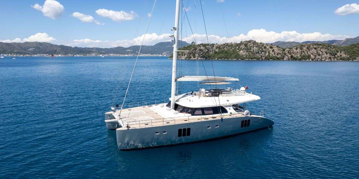
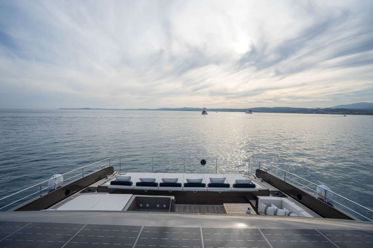
Zenit
78FT · POWER CATAMARAN
Desde €69,000/semana
8 Guests · 4 Cabins
Caribbean
Eastern Mediterranean
Western Mediterranean
South Pacific
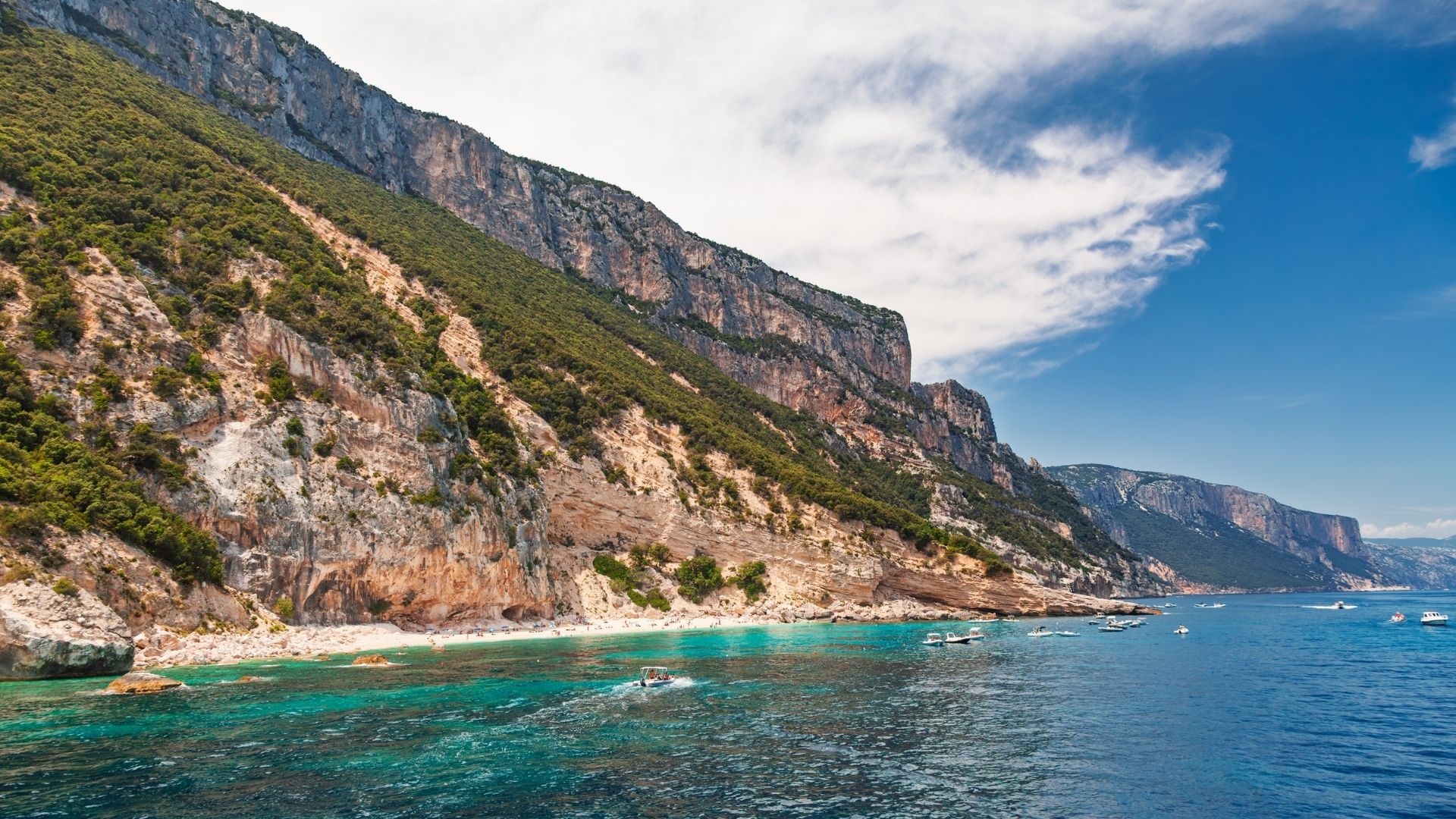
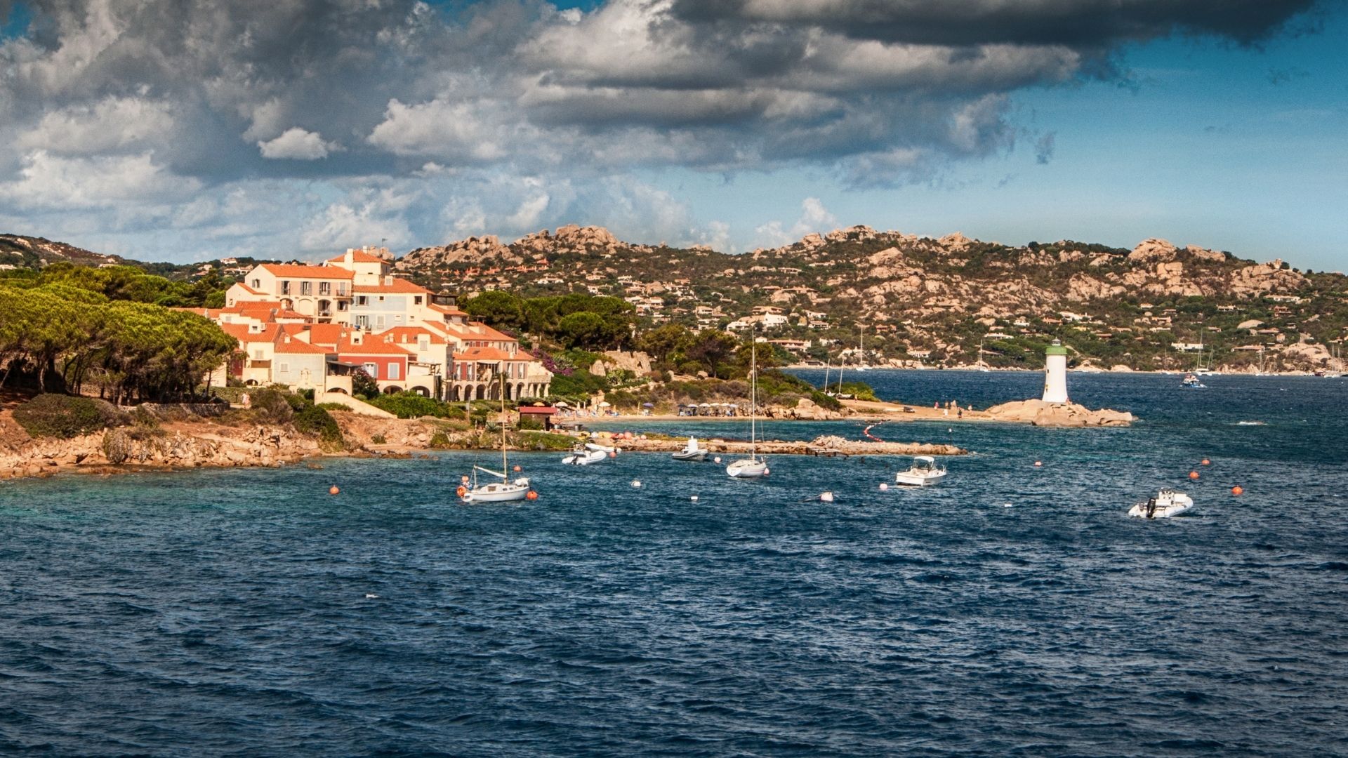
Dos países, seis millas náuticas entre ellos, una semana en yate con tripulación que abarca tanto Cerdeña como Córcega. La costa granítica de Costa Smeralda y las islas de granito rosa de La Maddalena en el lado italiano; la ciudadela medieval tallada en los acantilados de Bonifacio y la costa de roca roja de Scandola — Patrimonio de la UNESCO — en el lado francés. El contraste que cabe en siete días es lo que distingue a este destino de navegación de cualquier otro lugar en el Mediterráneo.
Por qué Cerdeña y Córcega
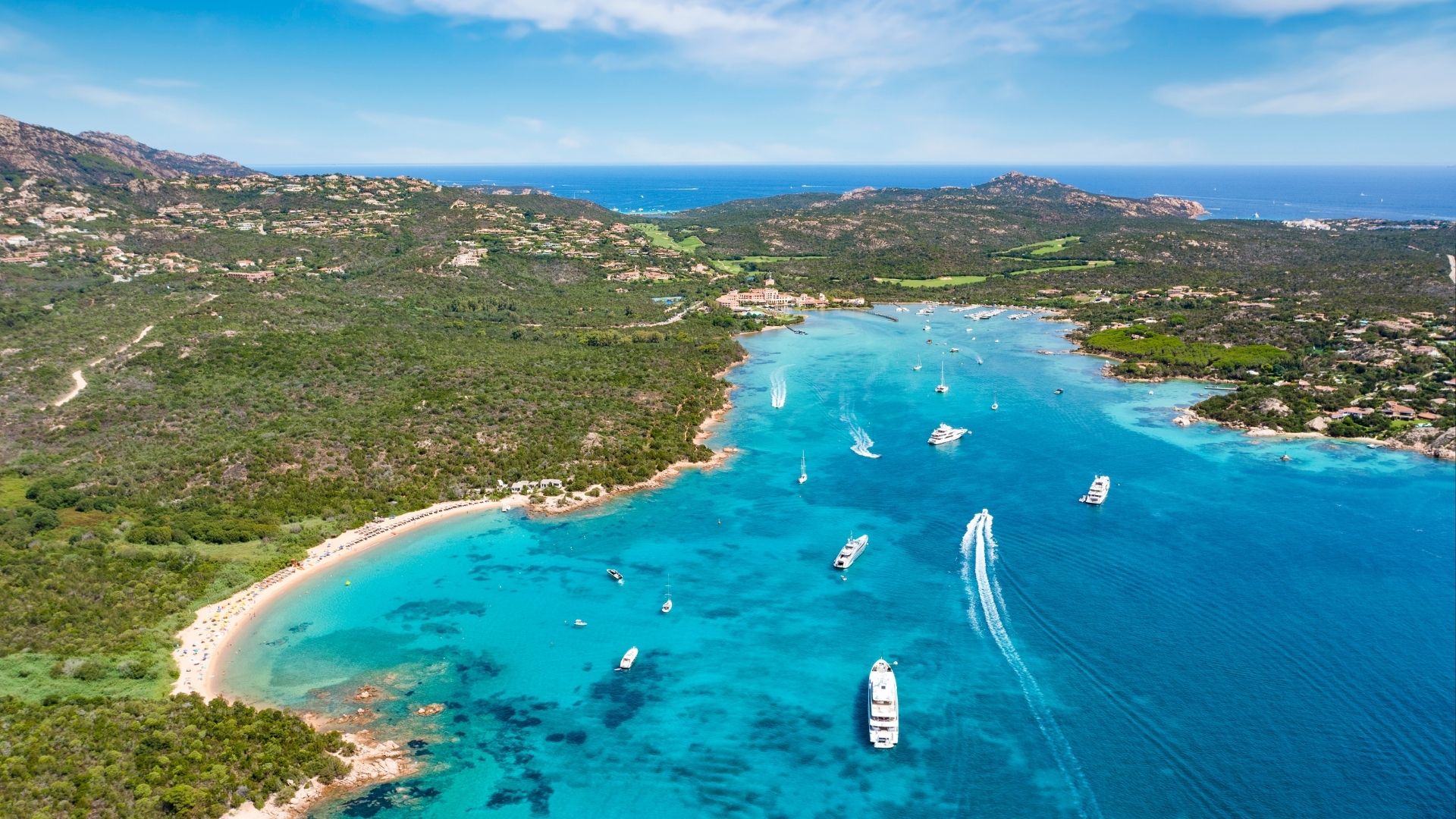
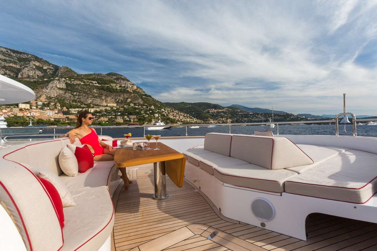
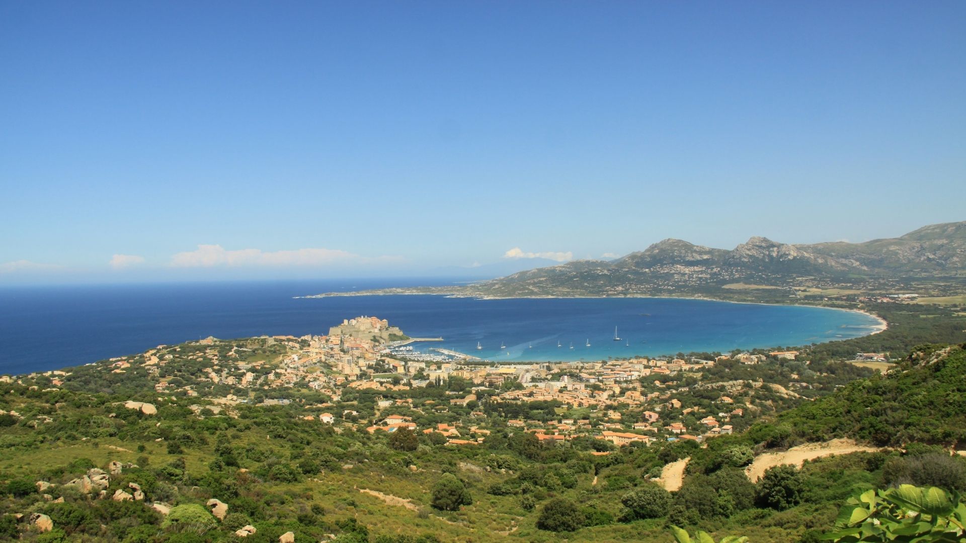
Este es el viaje por el Mediterráneo que la mayoría de nuestros huéspedes describe como el que soñaron durante años antes de reservar. Despertar anclados en la costa granítica de Cerdeña, en La Maddalena — afloramientos de granito rosa junto a la plataforma de baño, agua tan transparente que se ven treinta metros de profundidad. Almorzar en tierra en Phi Beach, sobre Baja Sardinia, el beach club construido sobre los acantilados que parece haber brotado de la roca. Al final de la tarde, cruzar seis millas náuticas de mar abierto y entrar en un puerto de fiordo en Córcega, con la ciudad medieval amurallada de Bonifacio elevándose justo encima. Dos países, un viaje en yate, seis millas entre Italia y Francia.
Diseñamos cuatro rutas por este destino de navegación, y el yate que elijas determina cuáles son realmente posibles. Los yates a motor cubren más distancia al día; los veleros cambian el alcance por la quietud de navegar a vela. El Circuito Cerdeña + Bonifacio y la ruta Norte de Cerdeña funcionan cómodamente con ambos tipos. La Costa Oeste de Córcega también es apta para cualquiera — el capitán toma las decisiones en los cabos de costa abierta según el pronóstico del Maestrale. La ruta premium de siete días en una sola dirección de Olbia a Mónaco — pasando por Bonifacio, Calvi, Saint-Tropez, Cannes, Cap Ferrat y Port Hercule en Mónaco — es exclusiva para yates a motor. Revisamos la ruta, el yate y las necesidades de tu grupo antes de confirmar la reserva.
El contraste que cabe en una sola semana es lo que distingue a este destino de navegación de cualquier otro en el Mediterráneo. Un almuerzo de marisco sardo en la Costa Smeralda — bottarga di Olbia rallada sobre fregola sarda, con una copa de Vermentino di Gallura. Una cena corsa tres noches después en la haute ville de Bonifacio — charcuterie de Corse, pescado fresco a la parrilla del barco de ese mismo día, una copa de Patrimonio rosé que casi nadie fuera de la isla ha probado. La arquitectura, la gastronomía, hasta el rosé cambian en el espacio de tres millas náuticas. Los sitios Patrimonio de la UNESCO de Scandola y las calanques de Piana comparten la misma semana de ruta con bahías de isla privada como Cala Coticcio y Lavezzi.
Cuatro características que distinguen al destino de navegación del Estrecho de Bonifacio del resto del Mediterráneo.
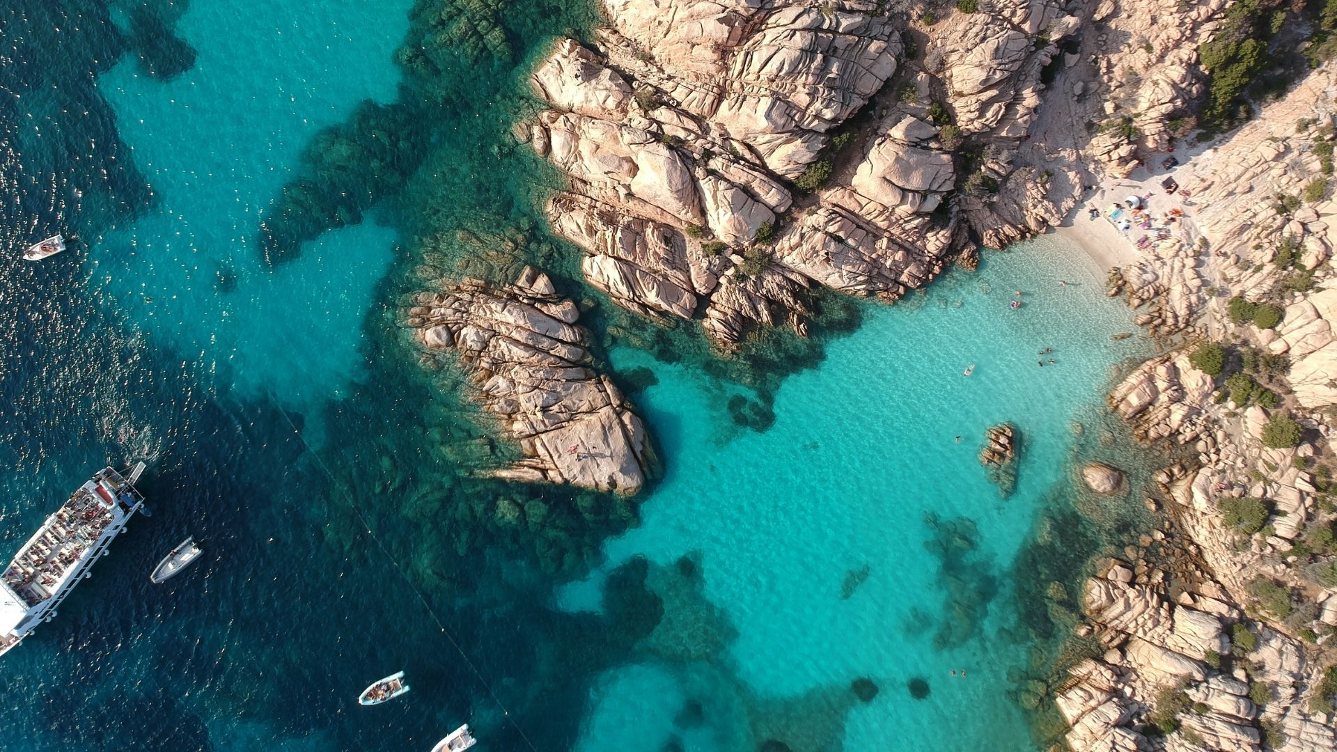
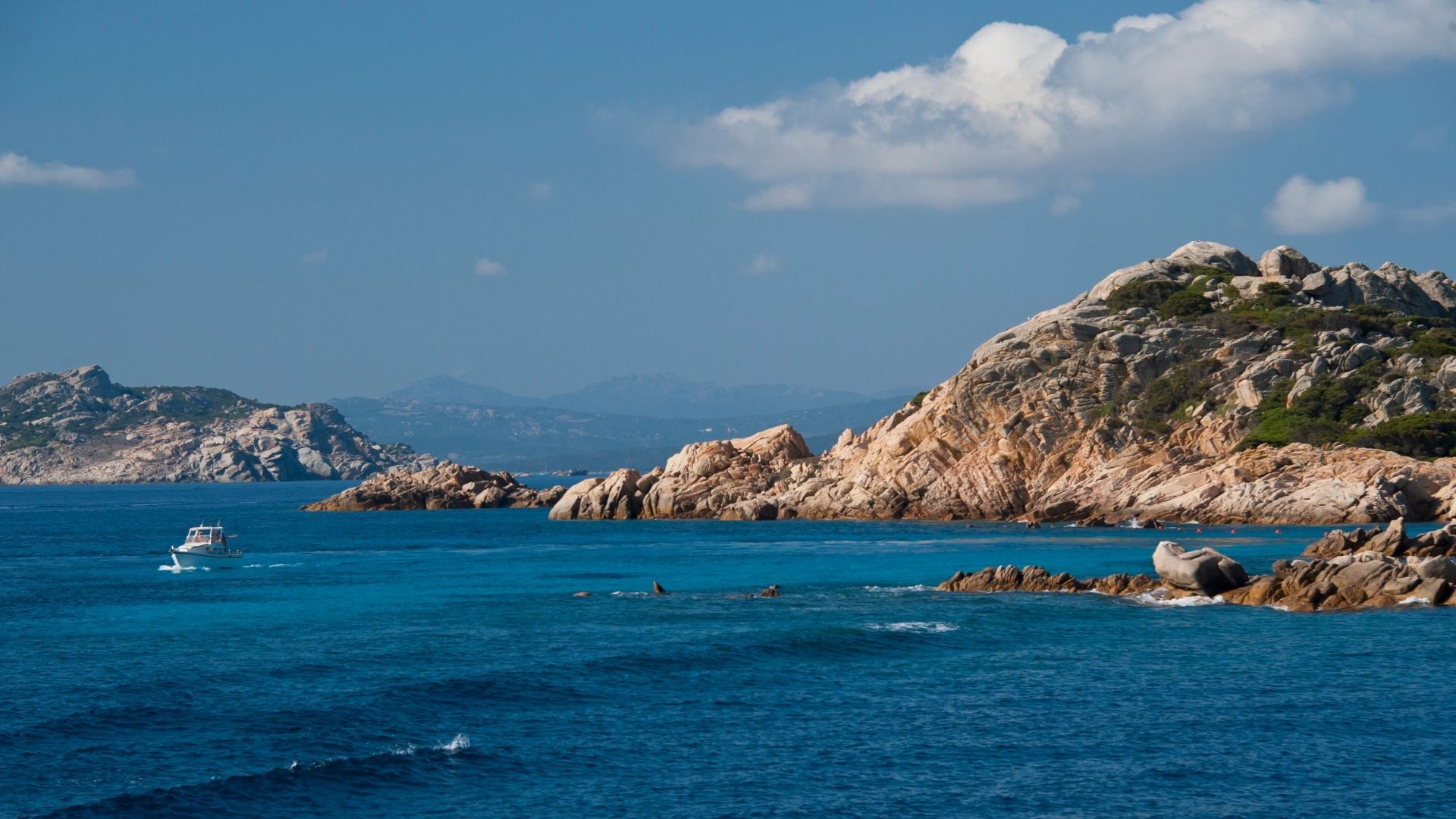
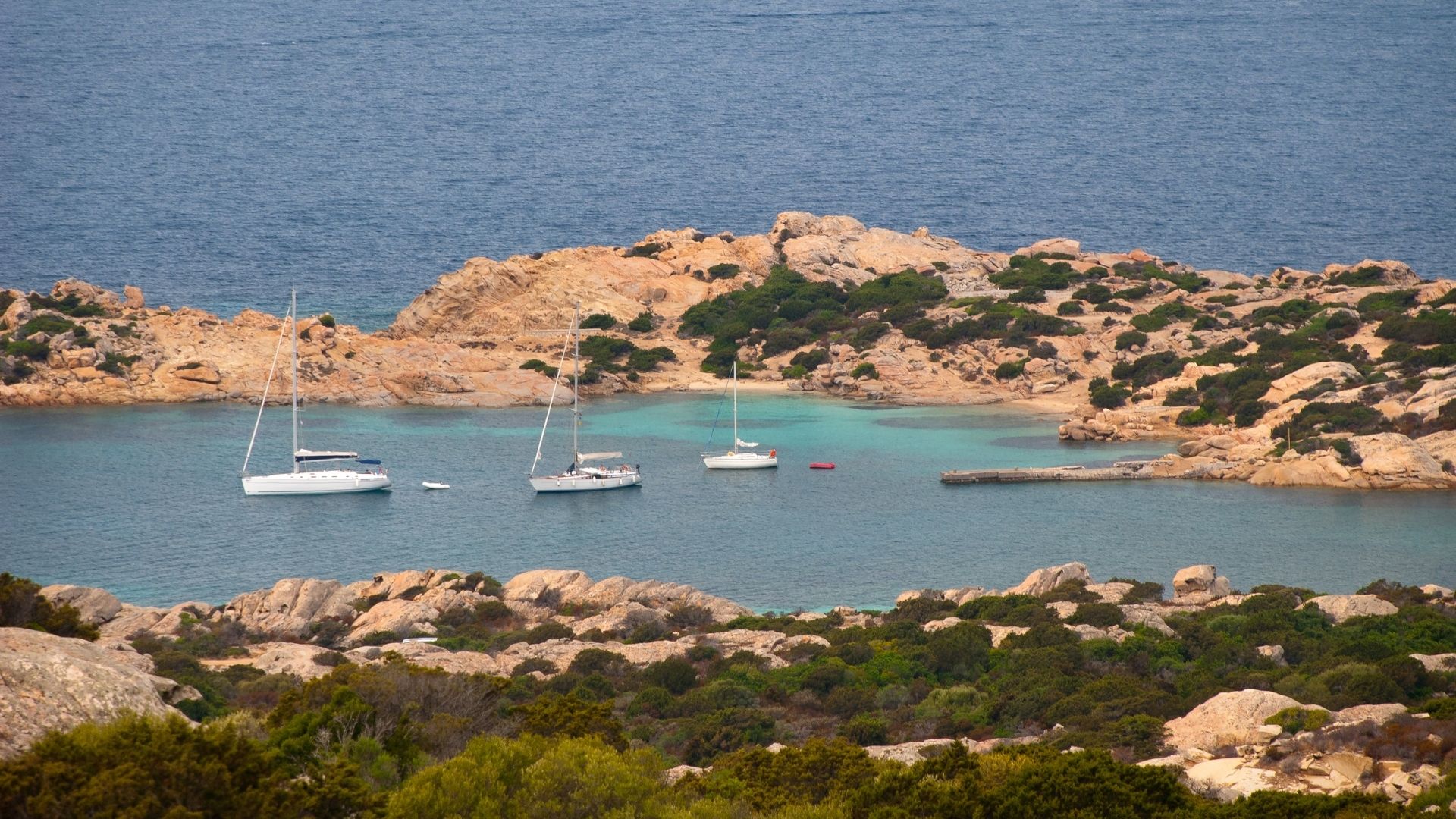
El lado sardo del estrecho recorre sesenta kilómetros desde el Cabo Figari hasta Santa Teresa Gallura — el tramo de costa granítica más concentrado del Mediterráneo. El pueblo de la Costa Smeralda sobre Porto Cervo Marina fue construido a mano en los años sesenta por un pequeño grupo de arquitectos del Aga Khan que se negaron a repetir ningún edificio; se puede recorrer a pie en veinte minutos. Al norte, cruzando el Canal de La Maddalena, las siete islas principales del Archipiélago de La Maddalena — Caprera, Spargi, Budelli, Razzoli, Santa Maria, La Maddalena y los cayos más pequeños entre ellas — se encuentran dentro de un parque nacional con campos de amarre gestionados y aguas tan cristalinas que el yate parece flotar sobre el fondo.
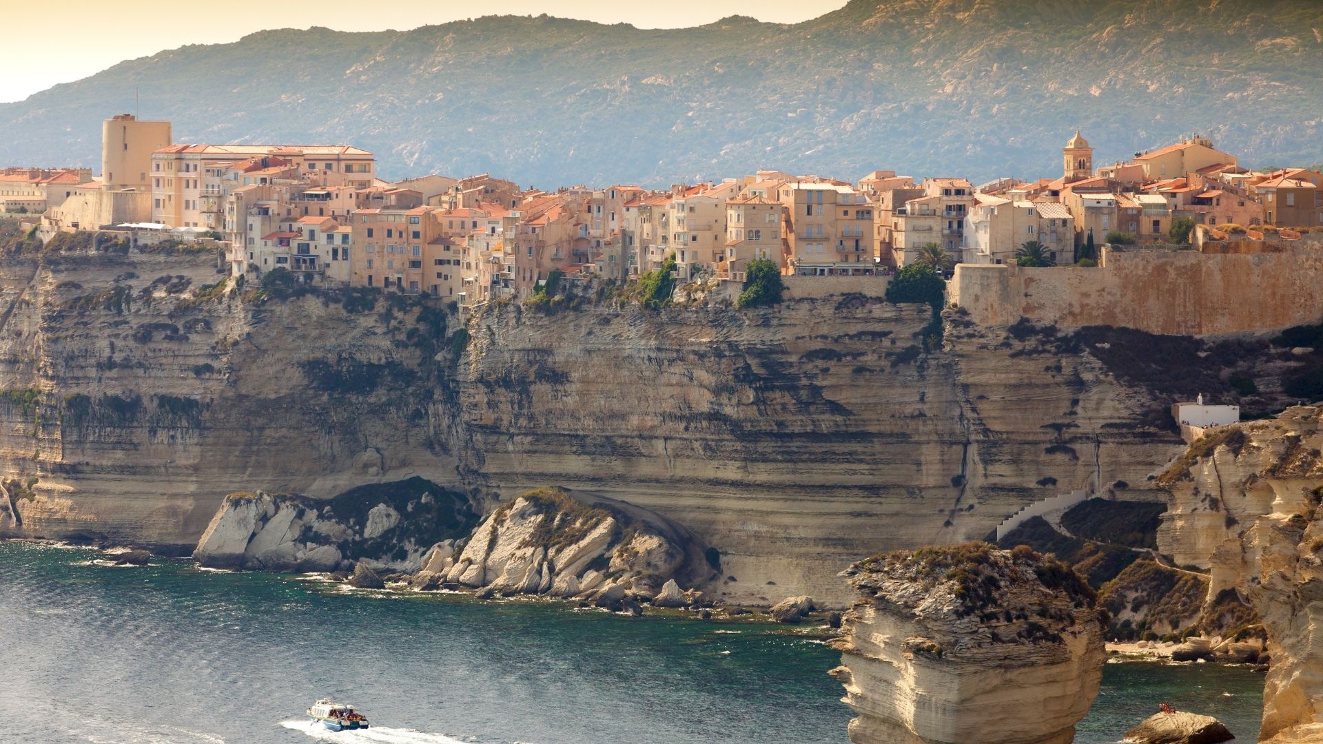
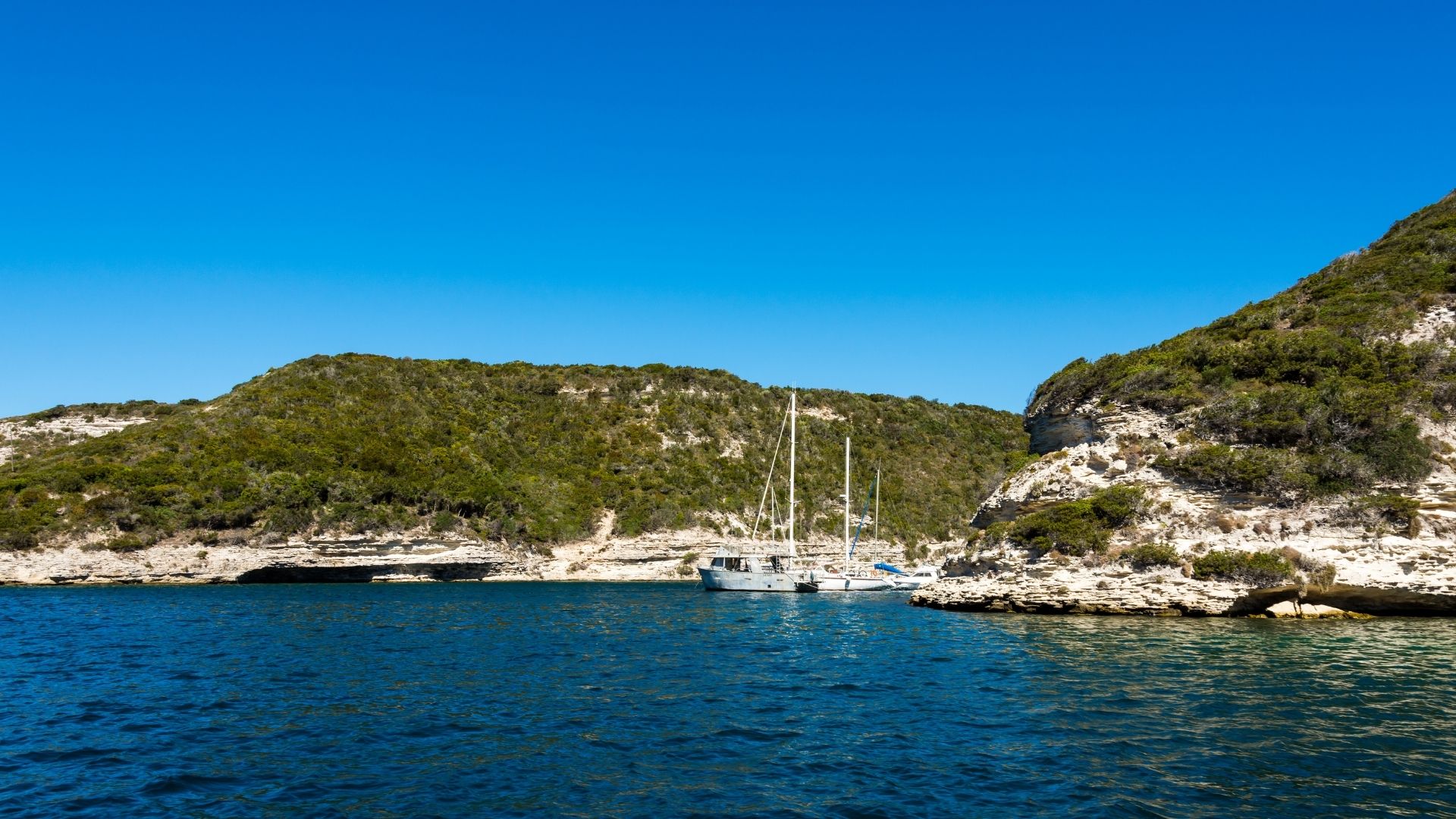
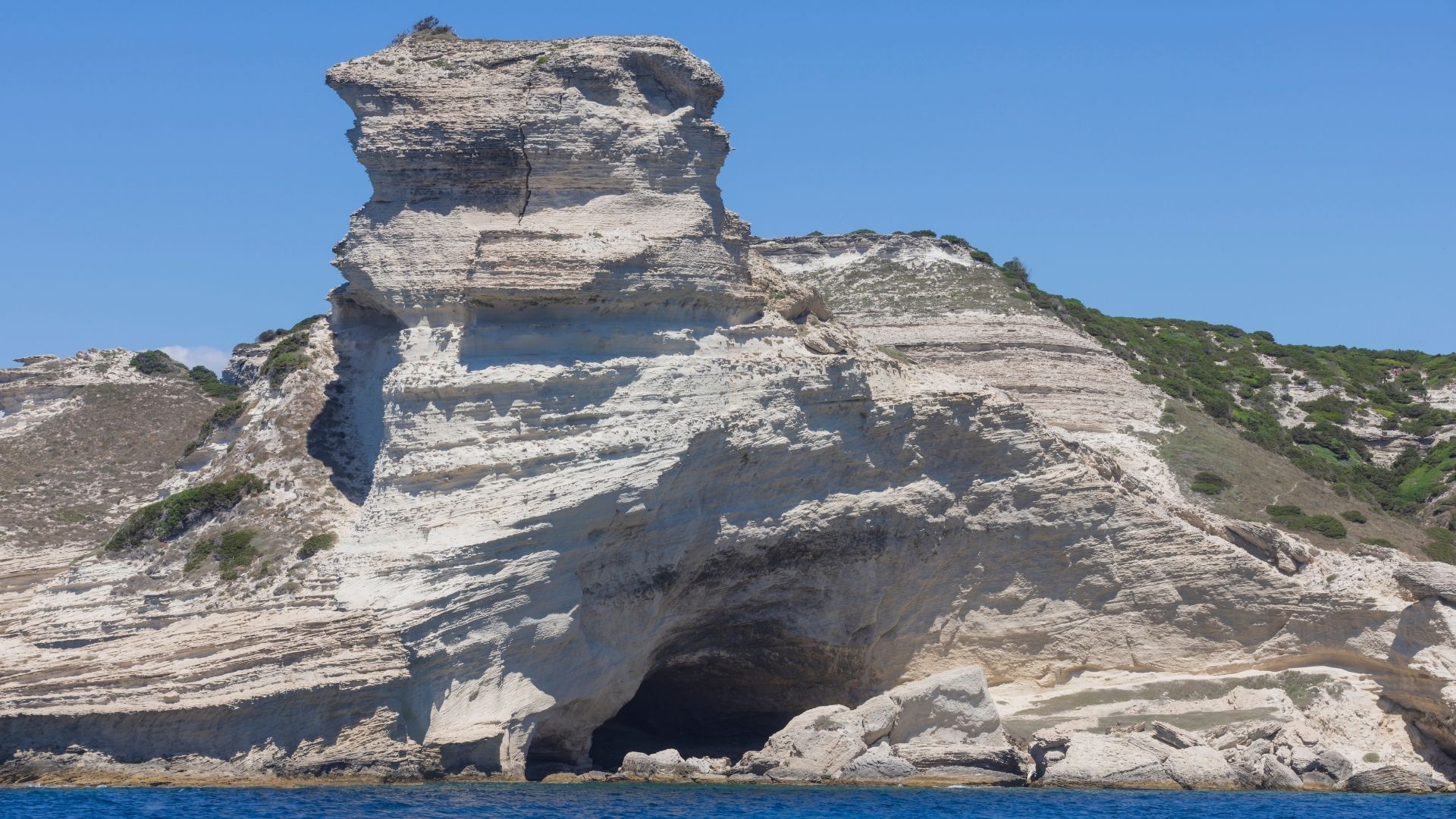
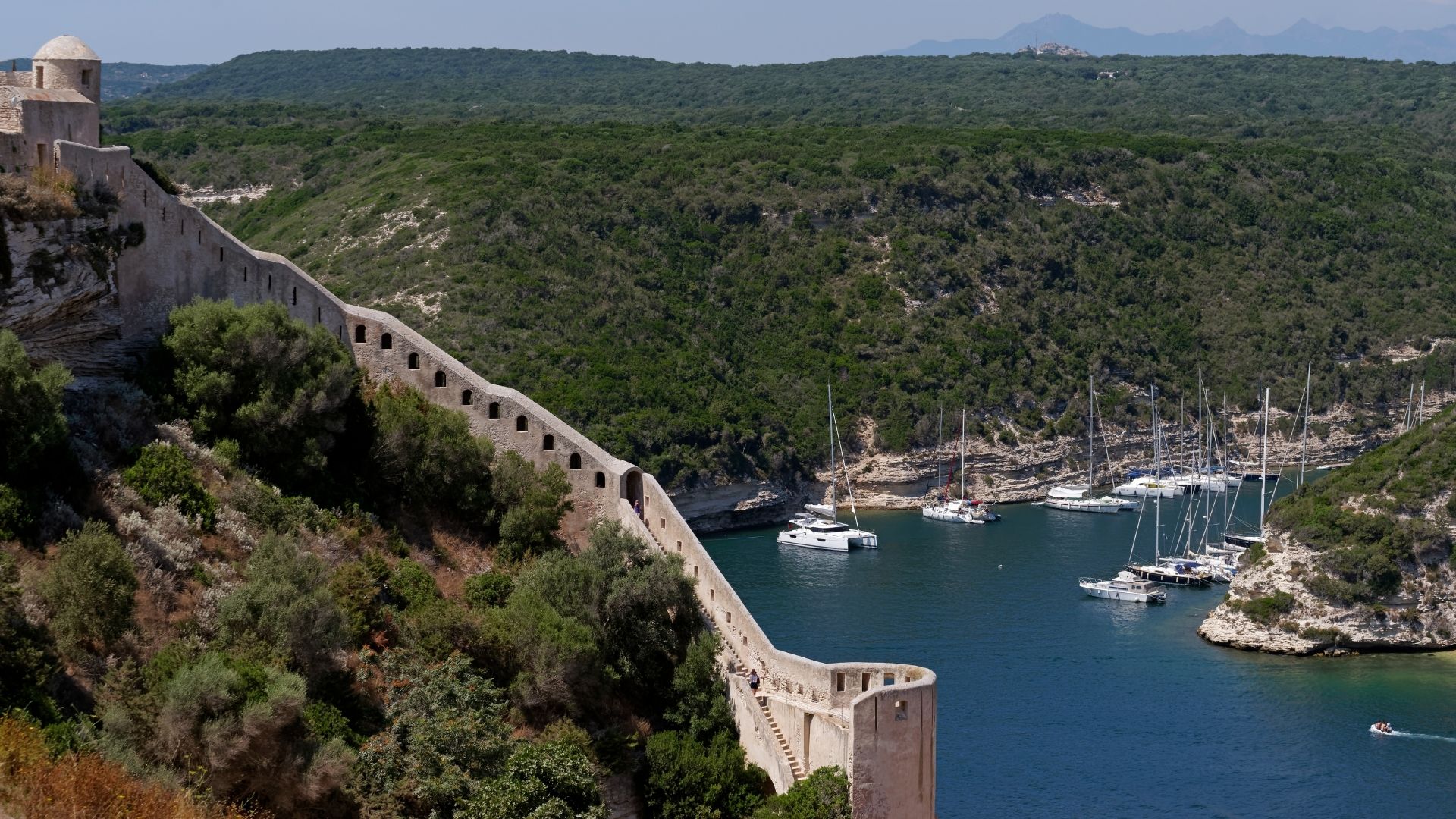
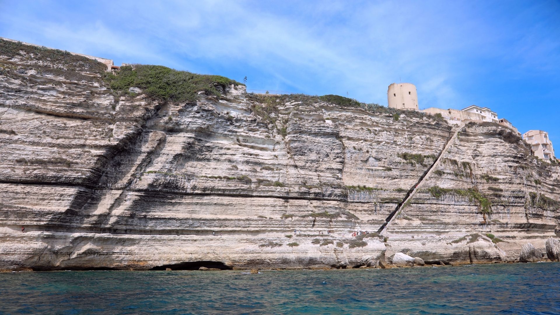
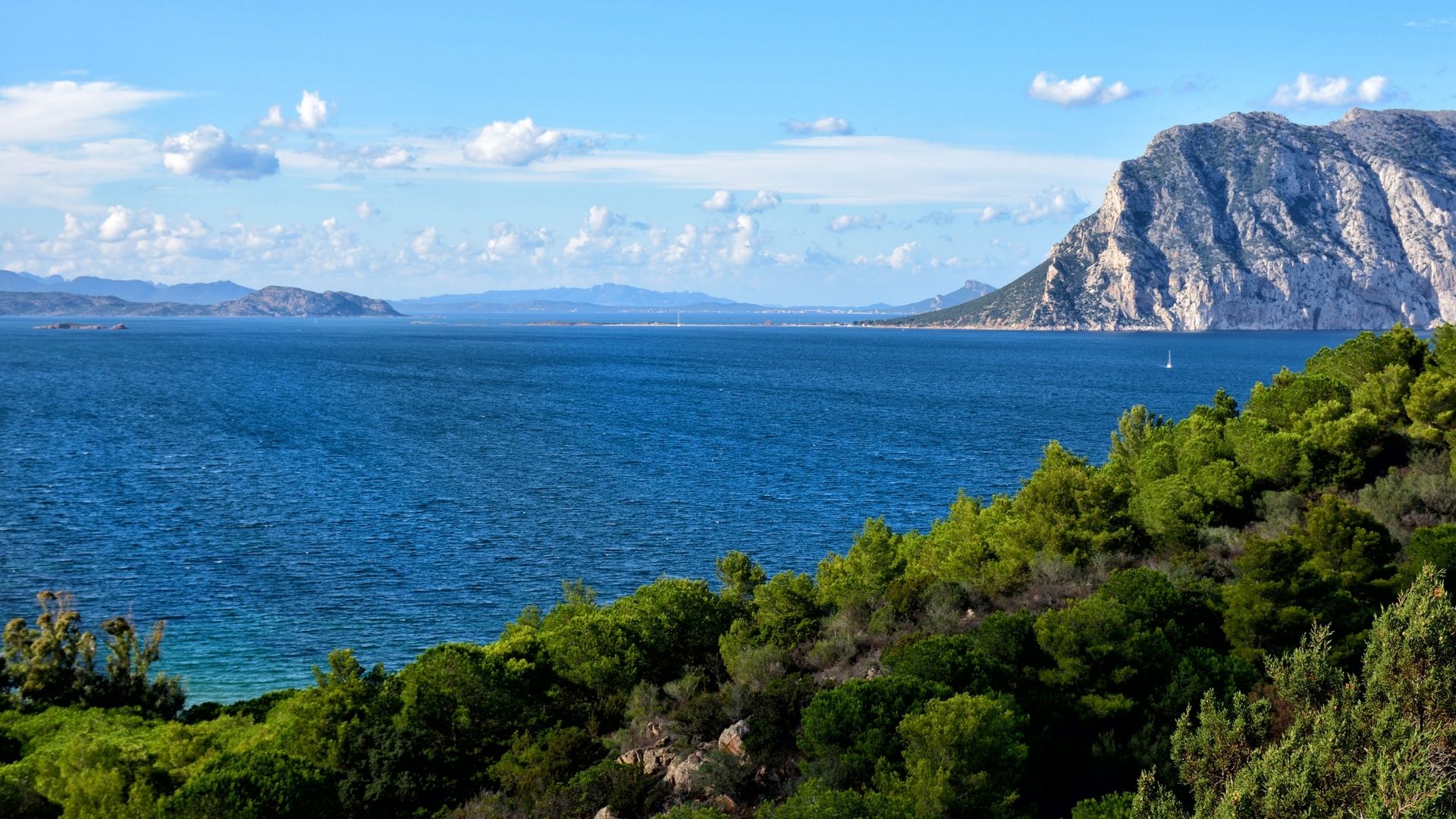
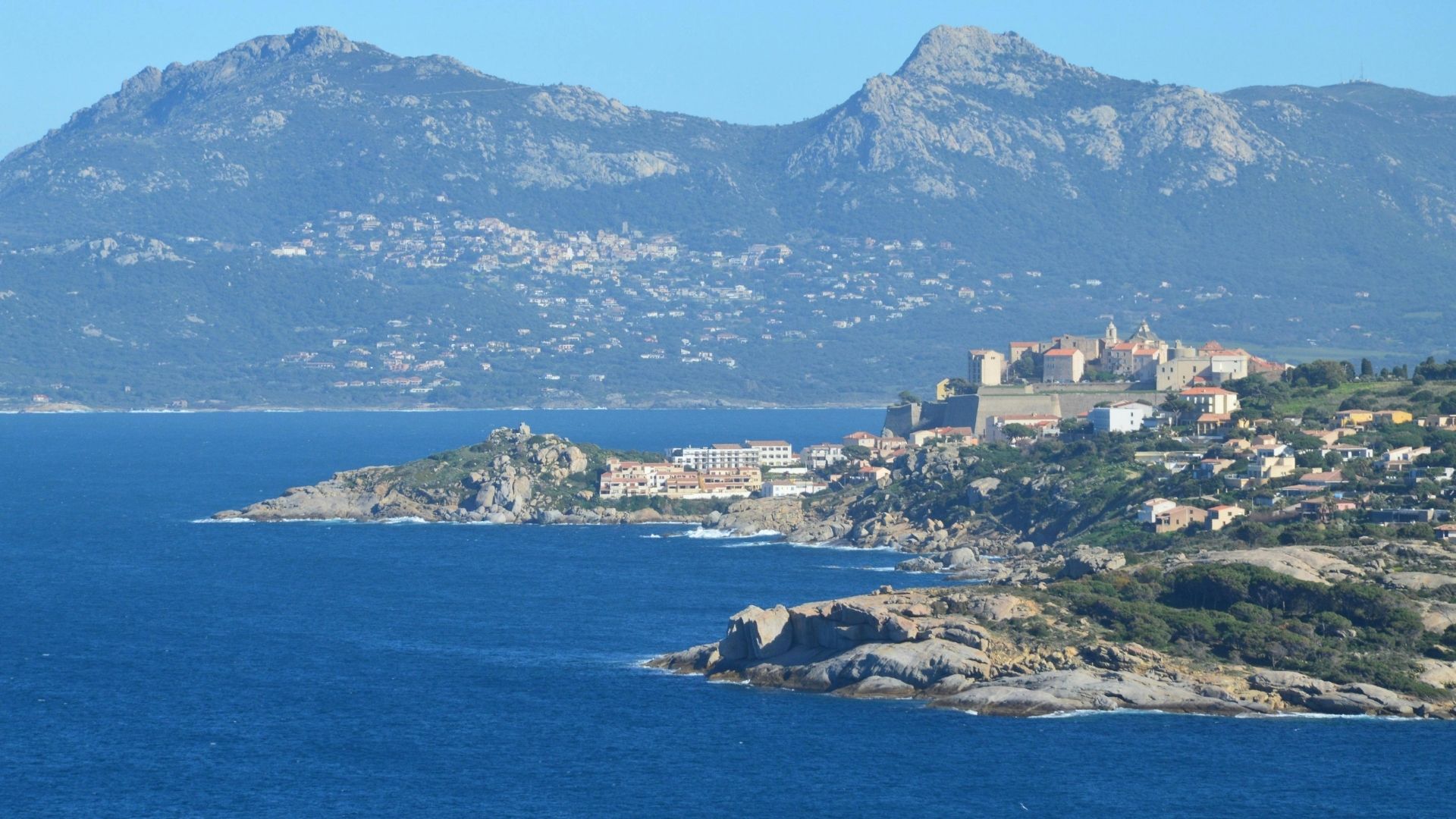
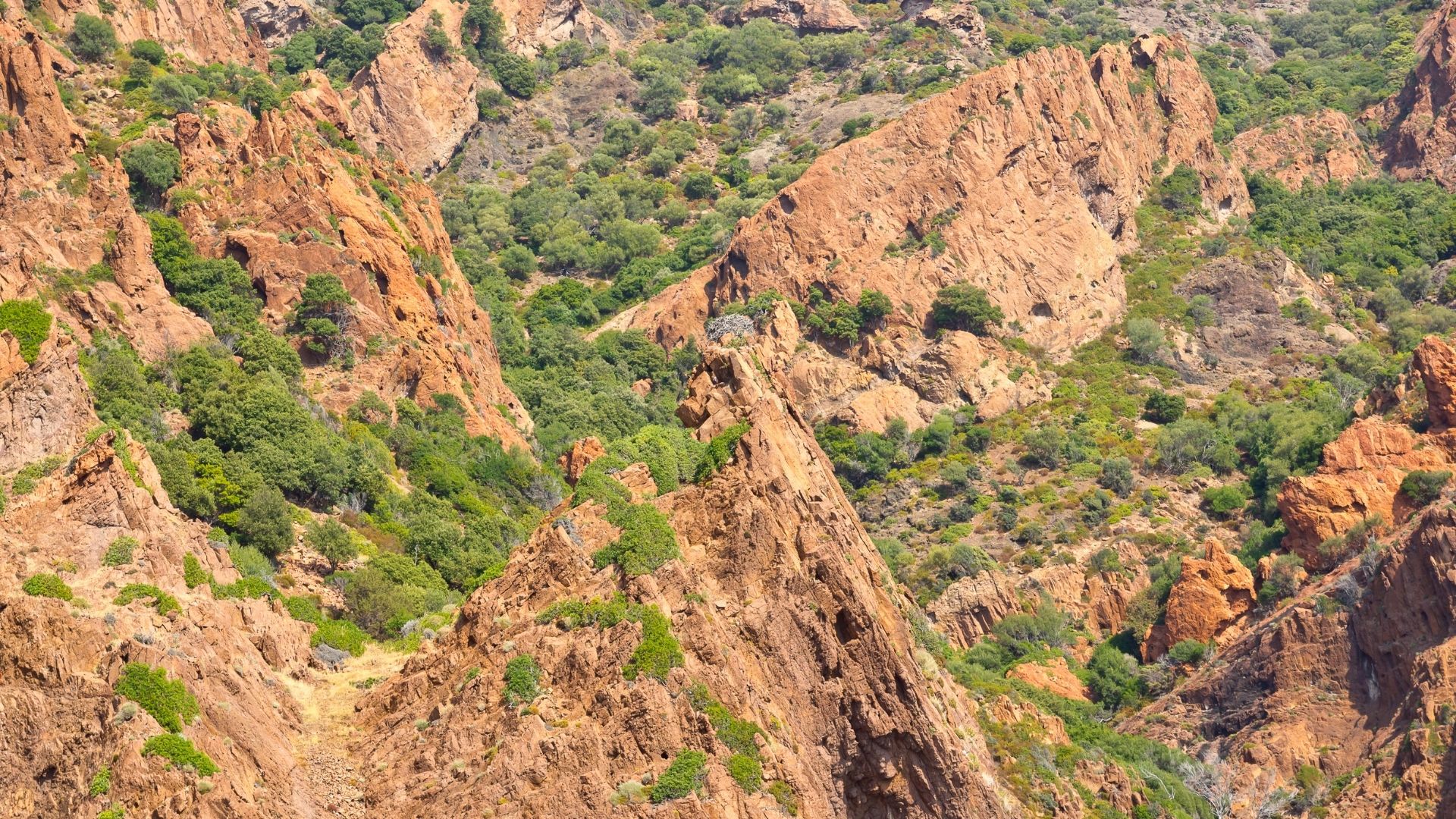
El lado corso del estrecho se abre con la haute ville de Bonifacio — una ciudad medieval amurallada construida sobre una península de acantilados calcáreos a seis kilómetros de la costa de Cerdeña, a la que se accede desde el agua a través de un canal en forma de fiordo esculpido en los propios acantilados. A veinticinco millas náuticas hacia el norte por la costa oeste, la Reserva Natural de Scandola es Patrimonio de la Humanidad de la UNESCO desde 1975: acantilados de pórfido rojo que caen al agua, cuevas marinas, grutas submarinas y la mayor colonia de águilas pescadoras en época de nidificación del Mediterráneo occidental. La reserva solo es accesible desde el mar — sin carretera ni acceso desde tierra —, por lo que un viaje en yate es la única forma práctica de verla. La siguiente bahía al sur es Girolata, un pueblo de pescadores al que solo se puede llegar en barco o tras cuatro horas de senderismo.
La gastronomía y el vino cambian de país en el espacio de tres millas náuticas. El lado sardo ofrece bottarga di Olbia (huevas de atún curadas, ralladas sobre pasta), fregola sarda con almejas, cochinillo asado bajo campana y un Vermentino di Gallura de carácter de los viñedos sobre suelo granítico de la Costa Smeralda. El lado corso ofrece charcuterie de Corse (los cerdos se alimentan de castañas y bellotas, y el prosciutto es notablemente diferente), pulenta con queso brocciu, el guiso de pescado local aziminu y Patrimonio rosé de los viñedos sobre suelo calcáreo en Cap Corse — un vino casi imposible de encontrar fuera de la isla. Una semana típica combina comidas preparadas por el chef a bordo con un almuerzo en tierra en Phi Beach en Cerdeña, una cena en una taberna de piedra al estilo konoba en Bonifacio y un tranquilo sundowner en Cala di Volpe de regreso.
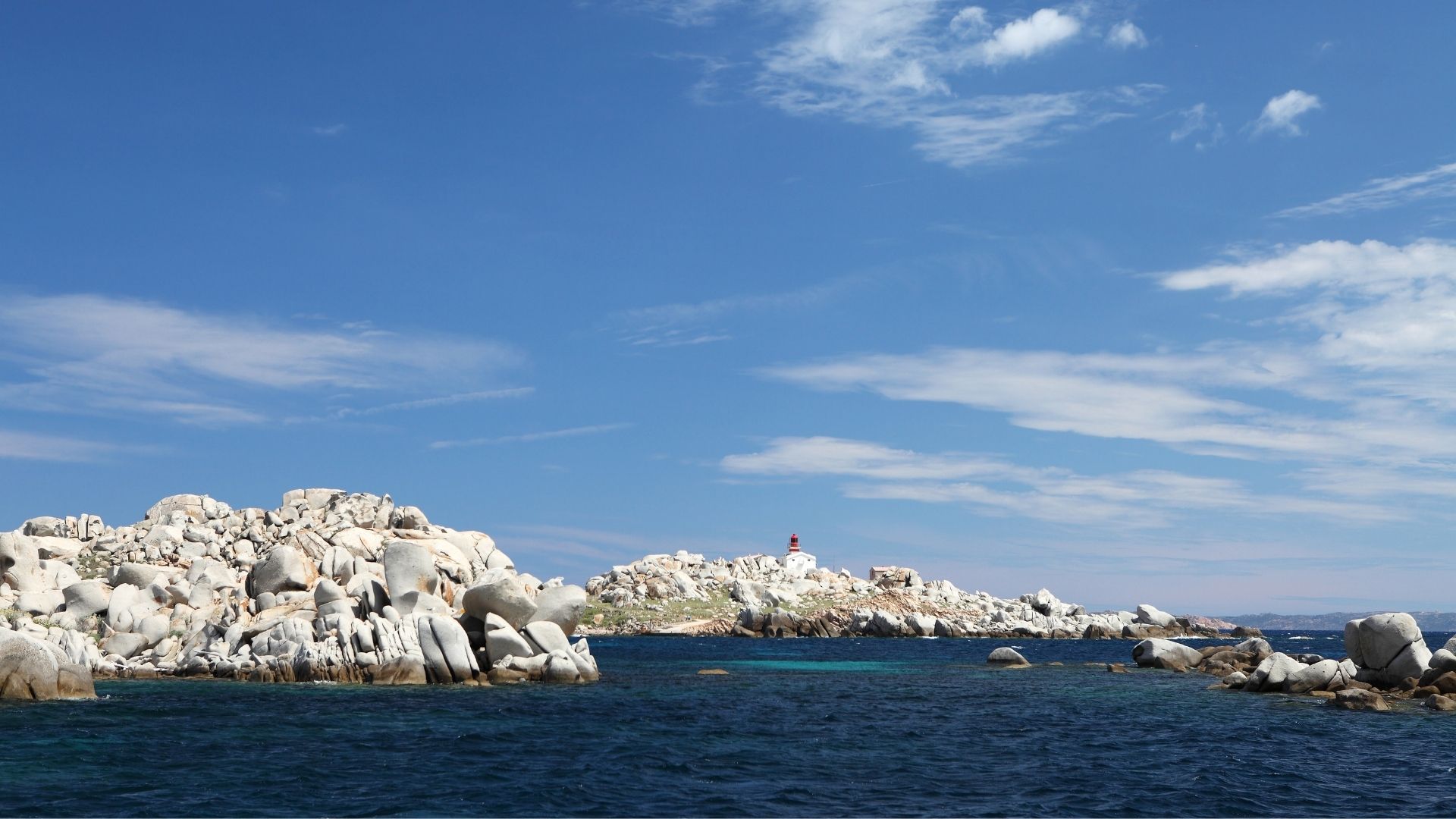
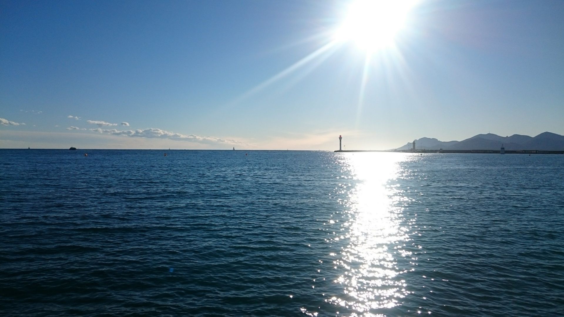
El estrecho en sí — seis millas náuticas de mar abierto entre las dos islas — alberga uno de los tramos de navegación más fotografiados del Mediterráneo. Las Islas Lavezzi se encuentran en el centro: una reserva marina francesa de afloramientos graníticos y aguas turquesas poco profundas, a treinta minutos de travesía desde Bonifacio y a cuarenta minutos desde La Maddalena. Cala Coticcio en Caprera (en el lado sardo, conocida como el "Tahití de Cerdeña") y la piscina natural de Cala di Roto en Spargi quedan justo al sur del estrecho. El cruce lo programa el capitán según el pronóstico del viento matinal — cuando el Mistral arrecia, el estrecho se agita; cuando está en calma, el agua está tan en llano que invita a nadar. El mejor día del viaje, en la mayoría de los casos.
A hand-picked selection of crewed charter yachts for Sardinia & Corsica — yachts and crews we know firsthand.
Your week is shaped around your group's interests, the season, and the conditions on the water — your captain tailors the days as they unfold. Treat these itineraries as starting points for inspiration.
Crewed Itinerary · Sardinia & Corsica
This Sardinia sailing itinerary is the bread-and-butter Sardinia & Corsica week — a seven-day round trip from Olbia that takes in the granite coast of Costa Smeralda, the seven major islands of the Maddalena Archipelago, the Strait of Bonifacio crossing into France, and the medieval cliff-citadel of Bonifacio itself. Roughly a hundred nautical miles end to end, with no leg longer than twenty-five and most days shorter. The Mistral fills in most afternoons through the summer; the captain reads the strait forecast at first light and times the crossing day around it. Two countries, one charter, six nautical miles of water between them.
The route is comfortable on a sailing yacht with the Mistral on the quarter and equally comfortable on a motor yacht. Most charterers running this route for the first time book it from Olbia and don't ask for a Côte d'Azur extension; they want to see the granite coast, sit at anchor in the Maddalena, walk the haute ville at Bonifacio, and have an unhurried dinner at Phi Beach before flying home. Your professional captain and private chef handle the rest.
This Sardinia sailing itinerary is the bread-and-butter Sardinia & Corsica week — a 7-day round-trip from Olbia that takes in Costa Smeralda's granite coast, the seven major islands of the Maddalena Archipelago, the Strait of Bonifacio crossing into France, and Bonifacio's medieval cliff-citadel. Two countries, one charter, six nautical miles of water between them. About 100 nautical miles total, no leg longer than 25.
The Mistral fills in most afternoons through the summer; an experienced captain reads the strait forecast at first light and times the crossing day around it. The route works on a sailing yacht with the Mistral on the quarter and equally well on a motor yacht. If you want the same week without the strait crossing, see the North Sardinia / La Maddalena itinerary; for the maximum-coverage Olbia-to-Monaco one-way, see the Two Islands + Côte d'Azur charter.
Day 1 of 7 · Olbia → Costa Smeralda
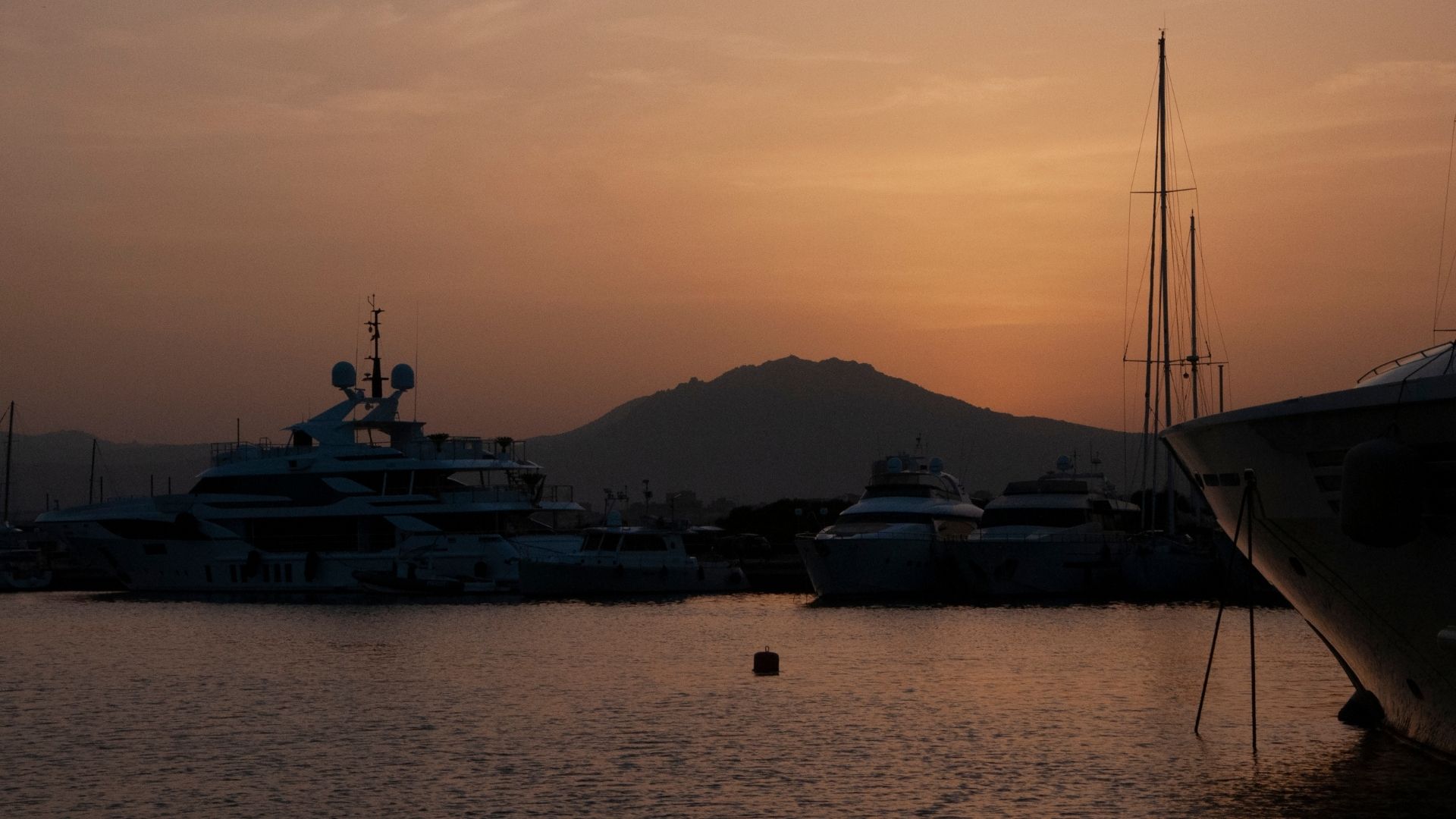
Your charter begins at Marina di Olbia, a fifteen-minute taxi ride from Olbia (OLB) airport on Sardinia's northeast coast. Your captain and chef meet you on the dock, walk you through the yacht, stow the luggage, and cover the chart for the days ahead — including the strait-crossing day mid-week, which the captain will time around the morning's Mistral forecast. The marina is deep-water capable for any size yacht, and the early afternoon is yours to settle in.
Once provisioning is squared away, lines off for the short sixteen-nautical-mile run northeast around Capo Figari and into the southern end of the Costa Smeralda. The Costa Smeralda is the most concentrated stretch of granite coastline in the Mediterranean — sixty kilometers from Cape Figari to Santa Teresa Gallura, with anchorages tucked into pockets of pink granite every two or three miles. Pevero Bay sits just south of Porto Cervo, framed by two white sandy beaches and protected from any direction the Mistral might be blowing.
First night at anchor in Pevero. Chef-prepared welcome dinner on the aft deck — bottarga di Olbia grated over fregola sarda with clams, a glass of Vermentino di Gallura from the granite-soil vineyards a few miles inland, and the lights of the Hotel Cala di Volpe across the bay coming on after sunset. The Mistral, if it's blowing, drops at dusk.
Day Highlights
Day 2 of 7 · Costa Smeralda → Maddalena
Slow morning at Pevero. Swim off the back of the boat, breakfast on deck, then a short afternoon reposition into Cala di Volpe — the deeper bay just north, with the eponymous hotel above the water and Phi Beach a few minutes' tender ride away. Lunch at Phi if the table works for the group: the beach club is built into the granite cliffs above Baja Sardinia, more rough-hewn than the polished resort version most guests imagine, and the food reads more authentic than the postcard.
By mid-afternoon, lines off for the eighteen-nautical-mile run north up the granite coast and across the Maddalena Sound to Caprera. The Maddalena Archipelago — seven major islands plus a scatter of smaller cays — sits inside a national park with managed anchoring fields, and Caprera is the second largest. Garibaldi lived out the back end of his life here; the house is now a museum, but most guests come for the granite coves on the south coast and the white-sand beaches on the east.
Evening at anchor off Caprera. The water turns the color of a pool light an hour before sundown. Dinner aboard tonight — chef-prepared, on the aft deck, with the lights of Maddalena town a couple of miles off the bow.
Day Highlights
Day 3 of 7 · Sardinia → Corsica
The strait day. Your captain checks the morning's wind forecast at first light: when the Mistral is settled, the strait is flat enough to swim across; when it's blowing twenty-five-plus, the captain may push the crossing to the afternoon or hold a day. The standard plan is mid-morning departure for a swim stop at the Lavezzi Islands — a French marine reserve of granite outcrops in the middle of the strait, six nautical miles from Bonifacio and seven from Maddalena, with shallow turquoise water and protected anchoring fields outside the no-anchor zones.
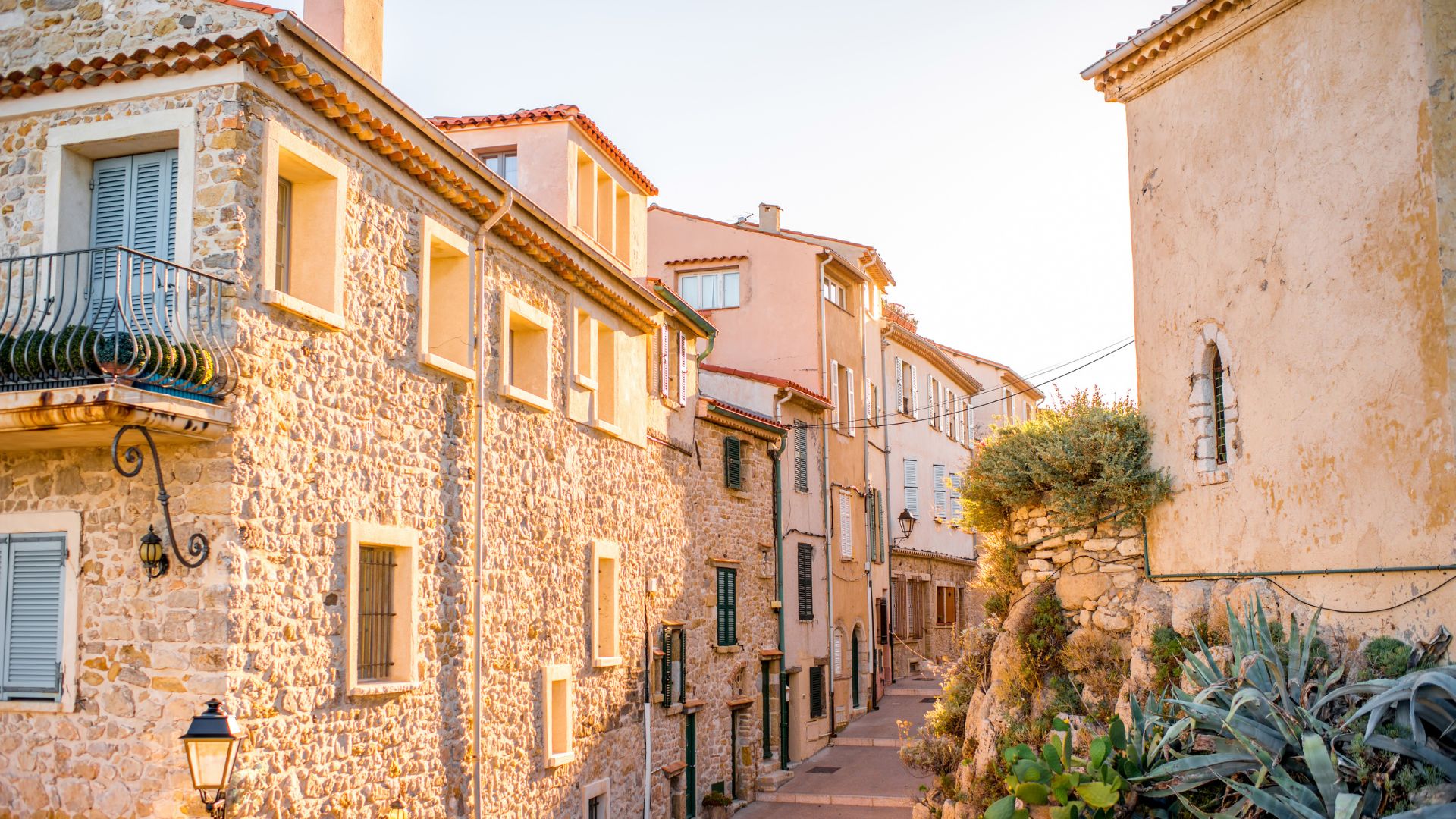
From Lavezzi the run into Bonifacio takes another forty-five minutes. The approach is unforgettable: the harbor is cut into the limestone cliffs themselves, and the yacht enters through a narrow fjord-like channel with the haute ville — the medieval walled town built on the cliff-top peninsula — rising directly above. The town has been there since the ninth century, and most of the wall still stands. Stern-to mooring inside the marina or anchor outside; the captain handles the booking.
Afternoon ashore. Walk the haute ville (twenty minutes around the perimeter, more if you stop at the chapels), down the King of Aragon Stairway — a hundred and eighty-seven steps cut into the cliff face, supposedly carved overnight by Aragonese soldiers in the fifteenth century — and across to the cemetery at the cliff edge with views back across the strait to Sardinia. Dinner ashore tonight at a stone-walled tavern in the haute ville: charcuterie de Corse, fresh-grilled fish off the day's boat, and a glass of Patrimonio rosé.
Day Highlights
Day 4 of 7 · Corsica → Sardinia
Slow morning in Bonifacio. Walk back into the haute ville for coffee, do the King of Aragon Stairway descent and climb if the group is up for it (the climb is the harder direction; allow forty-five minutes), and stop at the stone-walled cemetery at the cliff edge for the long view across the strait. By late morning, lines off and back across to Sardinia.
The return crossing is shorter — the captain steers a course toward Cala Coticcio on the east coast of Caprera, locally called the Tahiti of Sardinia. The cove is approachable only by tender; the granite boulders frame a half-moon of fine white sand and the water turns the color of a pool light. Anchor offshore, tender into the cove for an afternoon swim, and back aboard for a slow late lunch.
Evening reposition a few miles south to a quieter Caprera anchorage for the night. Dinner aboard tonight — chef-prepared, with the granite ridges of Caprera holding the last of the day's heat after sunset and the lights of the next yacht over (if there is one) a few hundred yards off the bow.
Day Highlights
Day 5 of 7 · Maddalena island day
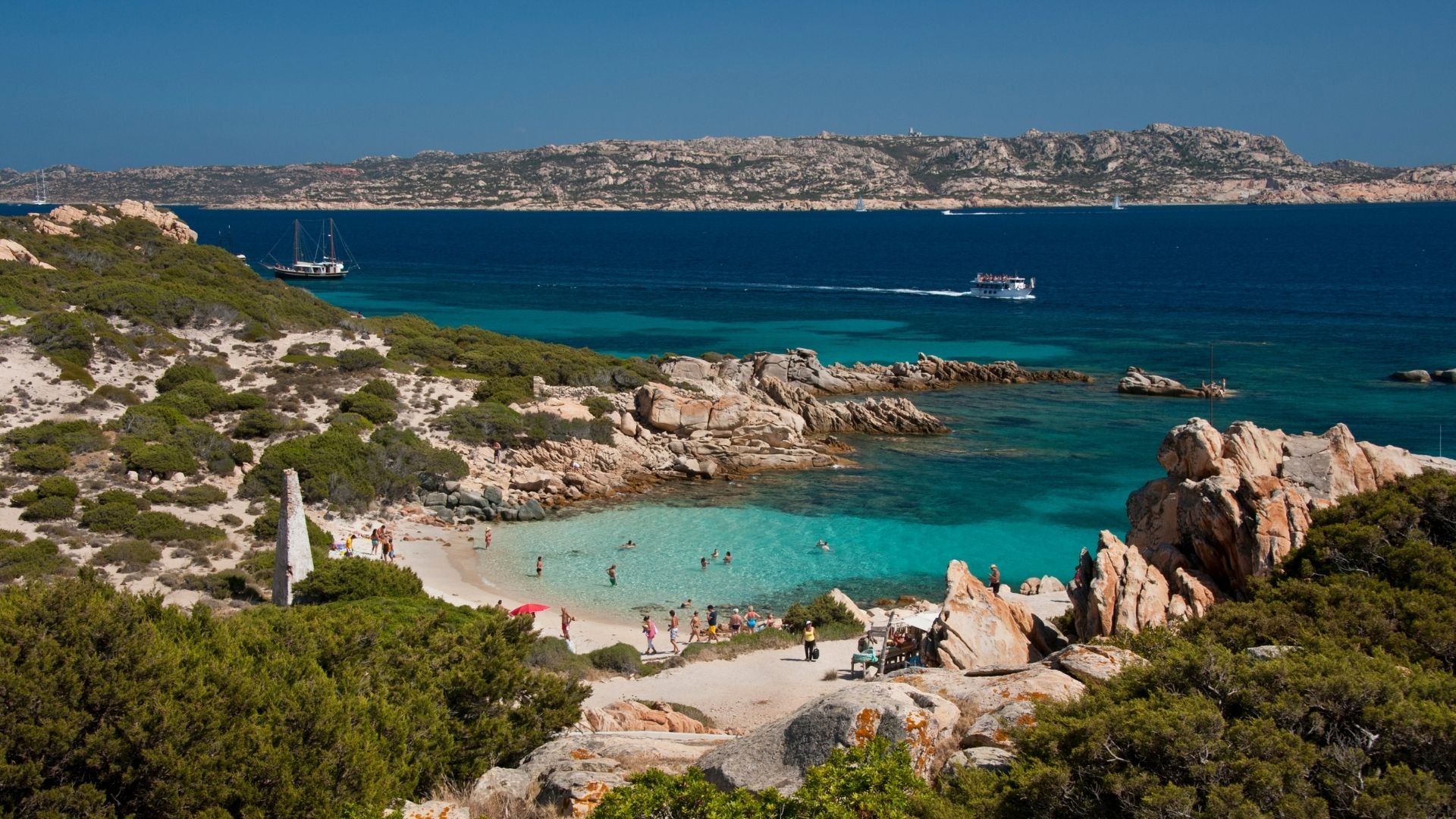
Today is the island day. Your captain repositions the yacht north into the cluster of smaller islands at the top of the Maddalena Archipelago — Spargi, Budelli, Razzoli, Santa Maria, and the small cays in between — for a full day of swim stops with no long passages. The first stop is Cala Corsara on the south coast of Spargi: a half-mile cove ringed by pink granite outcrops, the kind of water clarity that reads twenty meters of visibility on a calm day, and a managed anchoring field that limits how many yachts can sit there at once.
From Spargi a short tender-and-binoculars run takes you past Budelli's famous Pink Beach (Spiaggia Rosa), where strict look-only restrictions have been in force since 1994 — the pink color comes from microscopic coral and shell fragments and the beach is one of only two of its kind in the Mediterranean. Don't try to land; the harbor police monitor it. The look from offshore is the point. Razzoli sits just north of Budelli with a different shoreline texture, and Santa Maria — the most northerly of the cluster — has a long sand beach on its south side that's less visited than the headline anchorages.
Late afternoon, drop into Cala di Roto's natural pool. The pool is a sheltered shallow basin tucked at the back of the anchorage; it sits a few feet deep, turns a luminous turquoise mid-day, and stays glass-flat in any wind direction. Dinner aboard tonight, anchored in the cluster, the kind of evening that's the reason to have done the trip.
Day Highlights
Day 6 of 7 · Maddalena → Costa Smeralda
Slow morning swim off the stern, breakfast on deck, and a late-morning departure southbound. The captain works the route back along the Costa Smeralda's outer islands — Porto Rafael for a quieter midday stop, the granite headlands south of Cannigione, the small sand coves on the eastern shore of the Maddalena Sound that most yachts pass without anchoring.
Mid-afternoon, settle into Pevero Bay or Cala di Volpe — wherever the wind is best blocked. The Costa Smeralda is mostly a series of small bays inside larger ones, and most days the captain has options. Lunch ashore at Phi Beach if you missed it on Day 2, or a Costa Smeralda taverna ashore for an early dinner.
Evening aboard, anchored in the lee. The Costa Smeralda's last night is a slow one — the granite still holds the day's heat, the water turns from turquoise to navy as the sun drops, and the lights of Porto Cervo come up across the bay.
Day Highlights
Day 7 of 7 · Costa Smeralda → Olbia
Last full day. Slow morning at anchor — swim, breakfast on deck, a final tender ride into a quiet beach if the group wants one. By mid-day the captain works the short ten-nautical-mile run back south around Capo Figari and into the Gulf of Olbia.
Settle into Marina di Olbia in the early afternoon. Walk into Olbia town if you have the energy — the old town is small enough to cover in an hour, and a final lunch at one of the seafront restaurants is the unhurried close most groups take. Final chef-prepared dinner aboard tonight, anchored in the marina with the day's last light over the gulf.
Pack at your own pace. Your captain has the morning's transfer logistics already squared away.
Day Highlights
Day 8 · Departure
A last slow breakfast aboard at Marina di Olbia, a final swim off the stern if the harbor allows, and disembarkation by mid-morning. Your crew handles the transfer logistics: OLB is fifteen minutes by taxi, with direct summer flights to most major European hubs and an easy connection to the US East Coast through Rome, Milan, Frankfurt, or London. Step off with a passport that crossed one border the captain handled for you, a granite coast and a medieval citadel behind you, and the kind of week that makes most Mediterranean charter guests come back for the longer route.
Want to share or come back to this voyage later?
Bookmark this voyage →Crewed Itinerary · Sardinia & Corsica
This is the pure-Sardinia week — a seven-day round trip from Olbia that stays inside Italian waters, skips the Strait of Bonifacio crossing, and trades the Corsican stop for more time in Costa Smeralda and a longer pass through the Maddalena Archipelago. Roughly eighty nautical miles end to end, with no leg longer than twenty-two and most days under fifteen. The itinerary works on a sailing yacht or a motor yacht; the Mistral fills in most afternoons and the granite-coast anchorages catch the lee in any wind direction.
Most groups who book this route over the cross-strait version are guests who want to slow down, swim more, walk the Costa Smeralda twice rather than once, and skip the half-day spent on the strait crossing. Tavolara is the early-week stop most charters miss, the Maddalena cluster gets a full day instead of a half, and Cala Coticcio's tender-only access lands on a quieter evening at anchor. Your professional captain and private chef handle the rest.
This is the slow-pace North Sardinia itinerary — a 7-day round-trip from Olbia that stays inside Italian waters and skips the Strait of Bonifacio crossing. About 80 nautical miles total, no leg longer than 22. You trade the Corsican stop for more time in Costa Smeralda, a longer pass through the Maddalena Archipelago, and Tavolara Marine Protected Area on the early week — a stop most charters miss because they're racing to the strait.
The route works on a sailing yacht or a motor yacht; the Mistral fills in most afternoons and the granite-coast anchorages catch the lee in any wind direction. We send this North Sardinia itinerary to family groups, multigenerational charters, and anyone who'd rather walk Pevero Bay twice than burn a half-day on the strait. If you want the cross-strait version with Bonifacio's medieval citadel, see the Sardinia + Bonifacio Loop charter.
Day 1 of 7 · Olbia → Tavolara
Your charter begins at Marina di Olbia, a fifteen-minute taxi ride from Olbia (OLB) airport on Sardinia's northeast coast. Your captain and chef meet you on the dock, walk you through the yacht, stow the luggage, and cover the chart for the days ahead. Provisioning is squared away by early afternoon; lines off when the group's ready.
Most guests on this itinerary expect to head north toward Costa Smeralda on day one. The captain instead points the bow south for the twelve-nautical-mile run to Tavolara — a single limestone ridge rising five hundred meters straight out of the sea, designated as Italy's first marine-protected area. The anchorages on the lee side of Tavolara hold flat in any wind direction, the water visibility runs to twenty meters on a clear day, and the cruising traffic is a fraction of what's working the Costa Smeralda anchorages a few miles north.
First night at anchor in the lee of Tavolara. Chef-prepared welcome dinner aboard — Sardinian seafood, a glass of Vermentino di Gallura, the limestone ridge holding the day's heat after sunset and the lights of Porto San Paolo a couple of miles off the bow.
Day Highlights
Day 2 of 7 · Tavolara → Costa Smeralda
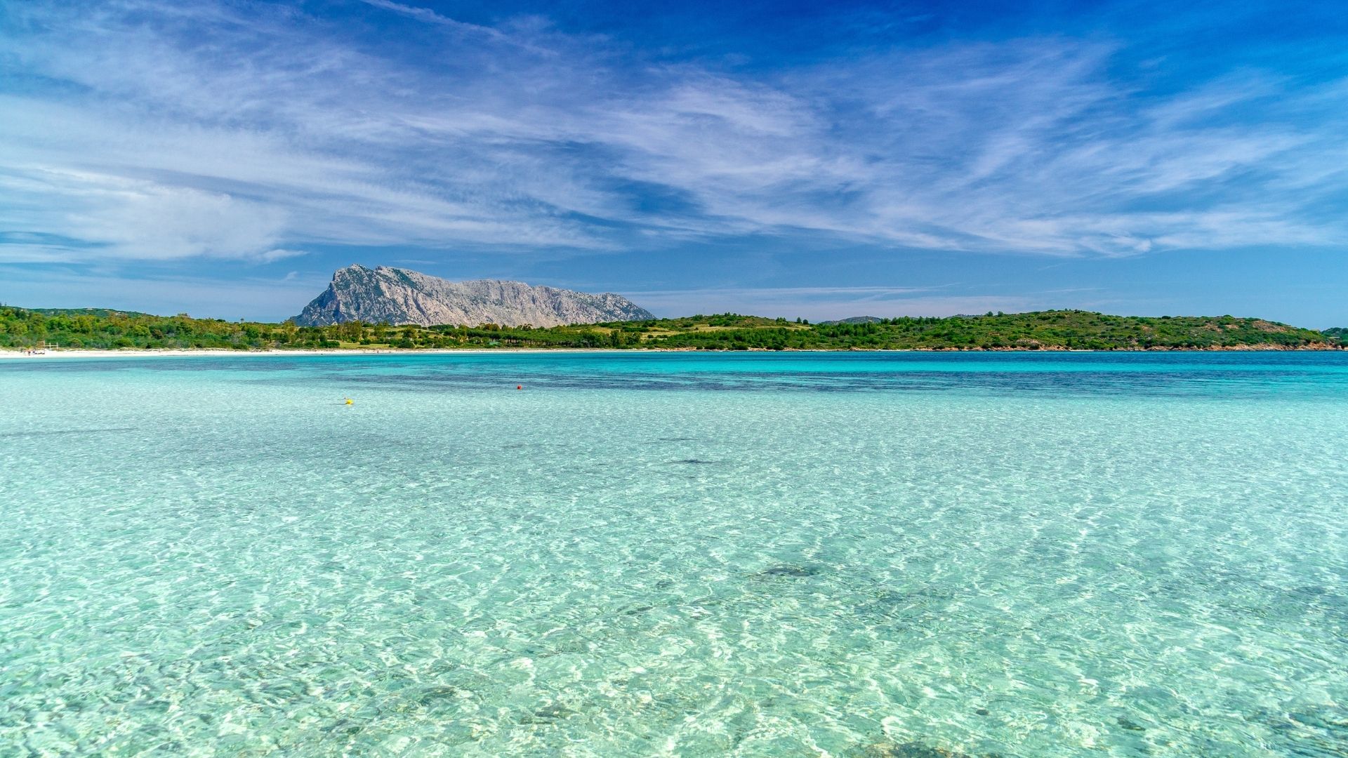
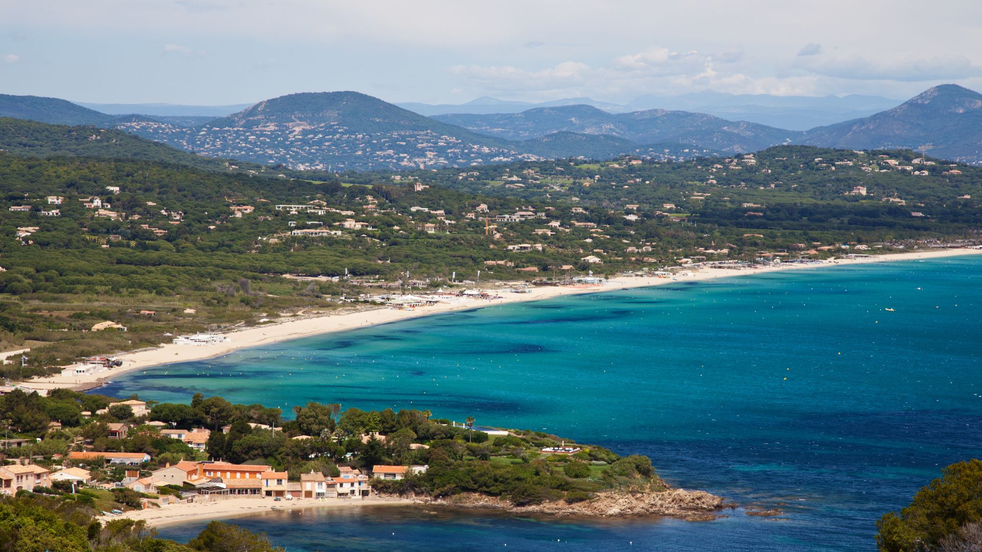
Slow morning at Tavolara — swim, breakfast on deck. Mid-morning lines off for a five-nautical-mile reposition north to Cala Brandinchi, Sardinia's south-east-coast version of "Tahiti of Sardinia" — a half-mile crescent of fine white sand backed by low scrub and stone pines, with shallow turquoise water that runs warm. Lunch at anchor, swim off the back of the boat.
Late afternoon, lines off for the longer fifteen-nautical-mile run north around Capo Figari and into the southern end of the Costa Smeralda. Cala di Volpe is the deepest sheltered anchorage on this stretch — sand bottom, Mistral protection, and the Hotel Cala di Volpe sitting on the headland above the water. The captain calls Pevero or Cala di Volpe based on the afternoon's wind, and you settle in for the first of two nights on the Costa Smeralda.
Dinner aboard tonight, in the lee of the granite ridges. Chef-prepared on the aft deck. The Costa Smeralda granite holds the day's heat after sunset; the water turns from turquoise to navy as the lights come up across the bay.
Day Highlights
Day 3 of 7 · Costa Smeralda day
Slow Costa Smeralda day. The captain may reposition five nautical miles between Pevero, Cala di Volpe, and Liscia di Vacca depending on the wind, but the route is short — most of the day is on the hook. Morning swim, paddleboard or kayak into the headlands, and a late-morning tender to Phi Beach for lunch if the table works. Phi is the beach club built into the cliffs above Baja Sardinia: open-air, granite walls, and a kitchen that runs Sardinian seafood-led with the occasional Italian-mainland classic.
Afternoon ashore: walk Porto Cervo's village above the marina — twenty minutes end-to-end, hand-built in the 1960s by a small group of Aga Khan's architects who refused to repeat any single building twice. The village is small enough that you'll cover it slowly with a stop at the Stella Maris church (a Vassily Kandinsky painting hangs inside) and a coffee at the piazza. Marina di Porto Cervo holds seven hundred slips and yachts to a hundred meters; walking the quayside reads more interesting than most guests expect.
Dinner aboard tonight or ashore at one of the Costa Smeralda restaurants — the captain books ahead. The Sardinian table is what most guests come back for: fregola sarda, suckling pig roasted under a bell, bottarga di Olbia grated over pasta, and a Cannonau red from the inland vineyards that doesn't travel well outside the country.
Day Highlights
Day 4 of 7 · Costa Smeralda → Maddalena
Slow morning on the Costa Smeralda — swim, breakfast on deck, optional walk into Cala di Volpe village if the group hasn't done it. By late morning, lines off for the fifteen-nautical-mile run north up the granite coast and across the Maddalena Sound to Caprera, the second-largest island in the archipelago.
The Maddalena Archipelago sits inside an Italian national park. Anchoring is managed — fields with mooring buoys in the heavily-trafficked coves, and the captain pays the per-yacht park fee online before crossing into the park boundary. The water turns the cleanest blue of the cruising ground, reading thirty meters of visibility on a settled day. Caprera holds Garibaldi's preserved house on its north coast (a museum, optional shore stop), but most charters come for the granite coves on the south coast and the white-sand beaches on the east.
Settle in for the night at one of Caprera's south-coast anchorages. Chef-prepared dinner aboard. The lights of Maddalena town a couple of miles off the bow.
Day Highlights
Day 5 of 7 · Maddalena island day
Today is the island day. Your captain repositions north into the cluster of smaller islands at the top of the Maddalena Archipelago — Spargi, Budelli, Razzoli, Santa Maria, and the small cays in between — for a full day of swim stops with no long passages. The first stop is Cala Corsara on the south coast of Spargi: a half-mile cove ringed by pink granite outcrops, the kind of water clarity that reads twenty meters of visibility on a calm day, and a managed anchoring field that limits how many yachts can sit there at once.
From Spargi a short tender-and-binoculars run takes you past Budelli's famous Pink Beach (Spiaggia Rosa), where strict look-only restrictions have been in force since 1994 — the pink color comes from microscopic coral and shell fragments and the beach is one of only two of its kind in the Mediterranean. Don't try to land; the harbor police monitor it. The look from offshore is the point. Razzoli sits just north of Budelli with a different shoreline texture, and Santa Maria — the most northerly of the cluster — has a long sand beach on its south side that's less visited than the headline anchorages.
Late afternoon, drop into Cala di Roto's natural pool. The pool is a sheltered shallow basin tucked at the back of the anchorage; it sits a few feet deep, turns a luminous turquoise mid-day, and stays glass-flat in any wind direction. Dinner aboard tonight, anchored in the cluster, the kind of evening that's the reason to have done the trip.
Day Highlights
Day 6 of 7 · Cala Coticcio + slow afternoon
Slow morning swim from the Maddalena cluster anchorage, breakfast on deck. Mid-morning, an eight-nautical-mile run southeast back toward the east coast of Caprera and Cala Coticcio — locally called the Tahiti of Sardinia. The cove is approachable only by tender; the granite boulders frame a half-moon of fine white sand, and the water turns the color of a pool light. Anchor offshore, tender into the cove for the morning, and back aboard for a slow late lunch.
Afternoon at anchor on Caprera's east coast. Water toys deployed — paddleboards, kayaks, snorkel kit. The captain may reposition a mile or two between coves depending on the afternoon's wind, but the day's miles are done. The Maddalena's quieter coves see only one or two yachts on a typical evening; on the Costa Smeralda you're never alone in an anchorage, but here you can be.
Dinner aboard tonight, the kind of last-night-but-one meal that the trip is built around. Chef-prepared, on the aft deck, with the granite ridges holding the last of the day's heat.
Day Highlights
Day 7 of 7 · Maddalena → Olbia
Last full day at anchor. Slow morning swim from Caprera, breakfast on deck. By late morning, lines off for the longest leg of the week — a twenty-two-nautical-mile run south along the Costa Smeralda's outer islands and back into the Gulf of Olbia. The captain may stop at Santa Teresa Gallura on Sardinia's northern tip for an optional walk through the working fishing harbor and the Spanish watchtower above it.
Settle into Marina di Olbia in the early afternoon. Walk into Olbia town if you have the energy — the old town is small enough to cover in an hour, and a final lunch at one of the seafront restaurants is the unhurried close most groups take. Final chef-prepared dinner aboard tonight, anchored in the marina with the day's last light over the gulf.
Pack at your own pace. Your captain has the morning's transfer logistics already squared away.
Day Highlights
Day 8 · Departure
A last slow breakfast aboard at Marina di Olbia, a final swim off the stern if the harbor allows, and disembarkation by mid-morning. Your crew handles the transfer logistics: OLB is fifteen minutes by taxi, with direct summer flights to most major European hubs and an easy connection to the US East Coast through Rome, Milan, Frankfurt, or London. Step off with the granite coast and the Maddalena behind you, and the kind of unhurried Italian week that most charter guests describe as the one they wished they'd booked the first time.
Want to share or come back to this voyage later?
Bookmark this voyage →Crewed Itinerary · Sardinia & Corsica
This is the wilder side of the Sardinia & Corsica cruising ground — a seven-day round trip from Ajaccio that runs the full west coast of Corsica, with the UNESCO red-cliff coast of Scandola in the middle of the week, the medieval citadel of Calvi at the northern turn, and a return south through Patrimonio's vineyards on Cap Corse. Roughly a hundred and fifty nautical miles end to end, with a Saint-Florent option for guests who want to push around the cape. The route works on a sailing yacht or a motor yacht; the open-coast headlands at Capo Rosso and the Scandola entrance can throw swell when the maestrale is up, and the captain reads the morning's forecast at first light.
Most groups who book this route over the cross-strait version are guests who've already done the Italian week or who want a more rugged Corsican cruising character: less polished anchorage culture, more village-walk fishing harbors, and the only UNESCO World Heritage marine reserve in the western Mediterranean. The food and wine register changes too — Corsican charcuterie, brocciu cheese, pulenta, and Patrimonio rosé from the chalk-soil vineyards on Cap Corse. Your professional captain and private chef handle the rest.
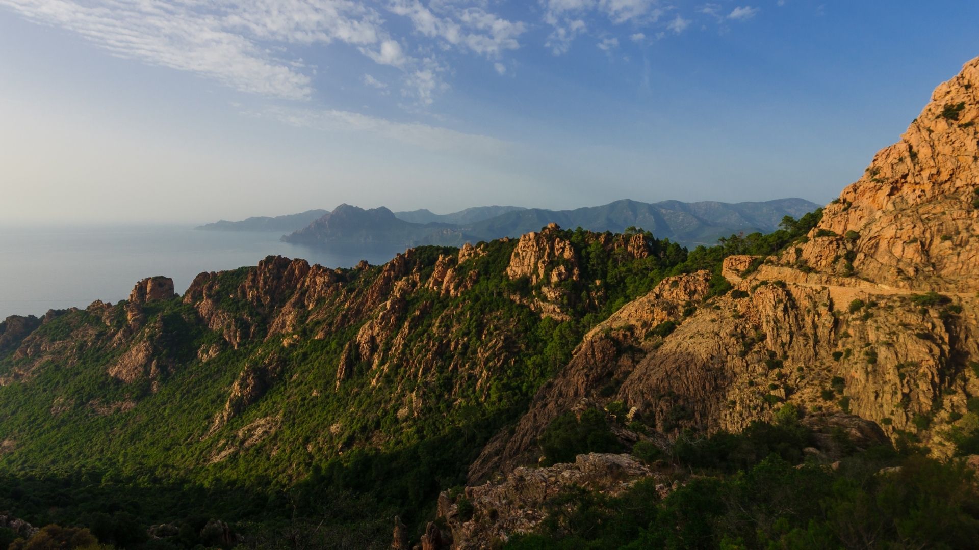
This is the wilder side of the Sardinia & Corsica cruising ground — a 7-day round-trip from Ajaccio that runs the full west coast of Corsica. UNESCO Scandola in the middle of the week (the only UNESCO World Heritage marine reserve in the western Mediterranean), the medieval citadel of Calvi at the northern turn, and a return south through the chalk-soil Patrimonio vineyards on Cap Corse. About 150 nautical miles total — meaningfully more ground than the Italian-waters loop, with payoff at every anchorage.
Most groups who book this Corsica itinerary over the Sardinia loop are guests who've already done the Italian week or who want a more rugged cruising character — less polished anchorage culture, more fishing-harbor villages, the Calanques de Piana red cliffs, and Girolata (a fishing village reachable only from the sea). The food register shifts too: Corsican charcuterie, brocciu cheese, pulenta, and Patrimonio rosé.
Day 1 of 7 · Ajaccio → Sanguinaires
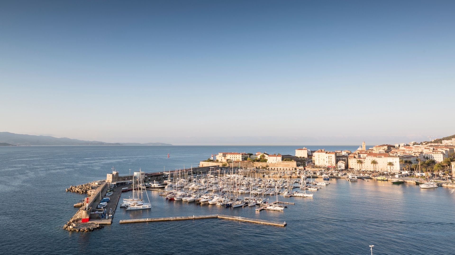
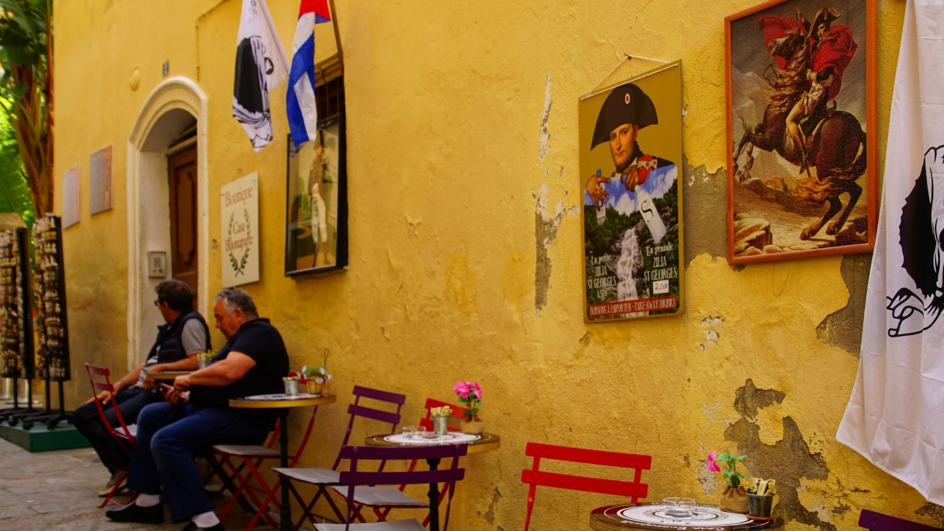
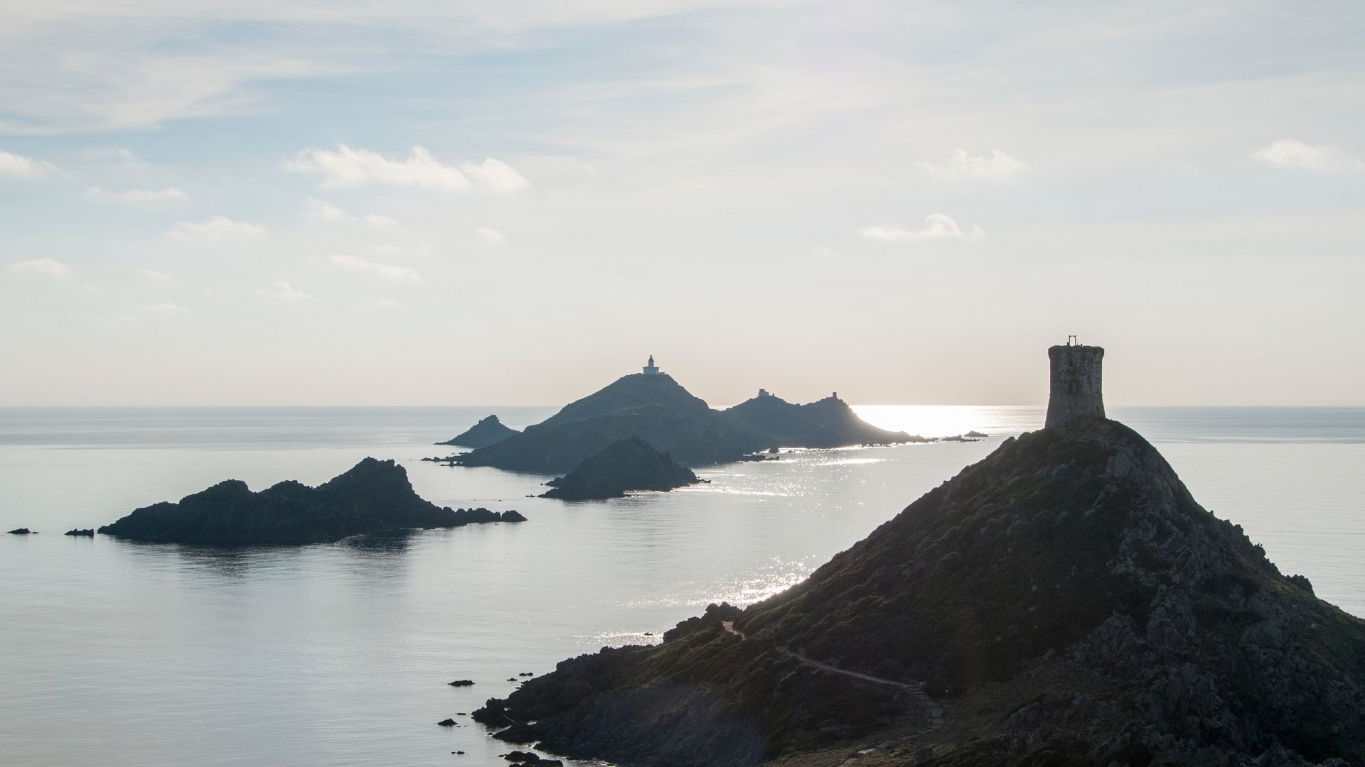
Your charter begins at Marina d'Ajaccio, a ten-minute taxi ride from Ajaccio (AJA) airport on Corsica's west coast. Your captain and chef meet you on the dock, walk you through the yacht, stow the luggage, and cover the chart for the days ahead. If you arrive early, Napoleon's birthplace house is a fifteen-minute walk through the old town, and the citadel above the harbor adds another half-hour if you're inclined.
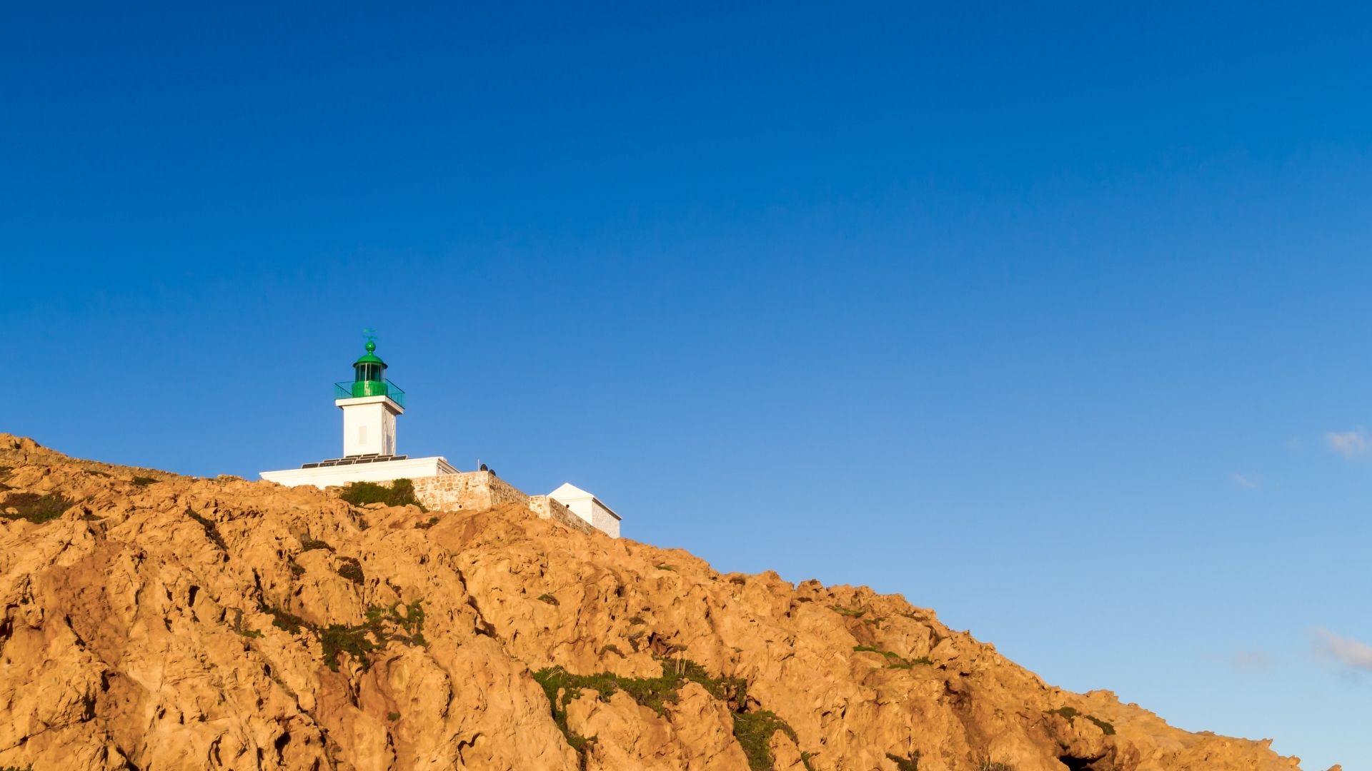
By early afternoon, lines off for the short ten-nautical-mile run out of the gulf to the Sanguinaires Islands — a chain of red-rock outcrops at the mouth of the bay, designated as a nature reserve and home to a population of Audouin's gulls. The islands take their name ("the bloody ones") from the way they turn deep red at sunset; the anchorage on the lee side holds in any westerly wind and the swimming off the back of the boat is the standard first-afternoon entry point.
First night at anchor in the lee of the Sanguinaires. Chef-prepared welcome dinner aboard — Corsican charcuterie to start, fresh-grilled fish off the day's boat, a glass of Patrimonio rosé from the vineyards on Cap Corse. The lights of Ajaccio glow back across the gulf as the sun drops behind the islands.
Day Highlights
Day 2 of 7 · Sanguinaires → Gulf of Porto
Slow morning at the Sanguinaires — swim, breakfast on deck, optional tender into the small lighthouse on the largest of the islands. By mid-morning, lines off for the twenty-five-nautical-mile northbound run up the west coast to Cargèse and the southern entrance of the Gulf of Porto.
Cargèse is a working coastal village with an unusual religious history: in the seventeenth century, a group of Greek Maniots fleeing Ottoman rule were granted land here by the Genoese authorities, and the village's two churches — Greek-Orthodox and Catholic — still sit opposite each other across the village square. Lunch ashore at one of the harbor restaurants is the standard mid-day stop. From Cargèse the captain works the run further north past Capo Rosso and into the Gulf of Porto.
Late afternoon, settle into an anchorage inside the gulf — the Calanques de Piana sit on the southern shore of the gulf entrance, a stretch of wind-eroded red porphyry cliffs designated UNESCO World Heritage in 1983. The cliffs catch the late-afternoon sun and turn the color of the desert. Dinner aboard tonight in the lee of the calanques.
Day Highlights
Day 3 of 7 · Scandola UNESCO + Girolata
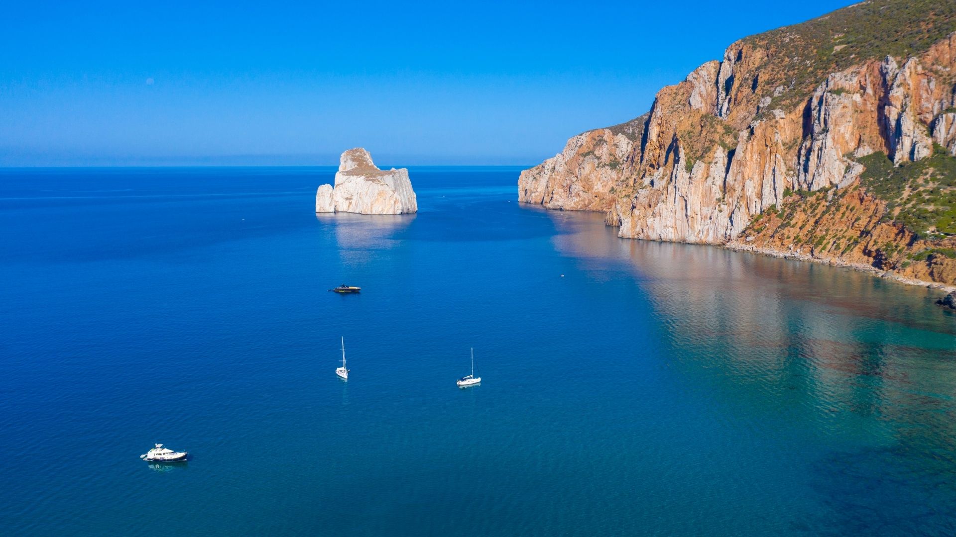
Today is the marquee day. Mid-morning lines off for the short ten-nautical-mile run north along Corsica's west coast and into the Scandola Nature Reserve — designated a UNESCO World Heritage Site in 1975 and accessible only from the water. The reserve runs nine kilometers of coast: red porphyry cliffs that drop straight into the sea, sea caves carved into the rock, and the densest population of nesting ospreys on the western Mediterranean. There is no shore access, no road, and no village; the protection is strict, and the captain follows the marked anchoring restrictions and minimum-distance rules at the cliff faces.
From Scandola a short tender or daysail brings you into Girolata, a fishing village on the southern shore of the gulf that's reachable only by boat or by a four-hour hiking trail through the Scandola hinterland. Twenty houses, a fishing harbor, a small Genoese fort overlooking the bay, and a population under fifty year-round. Lunch ashore at one of the two harbor restaurants — the catch is whatever came up that morning, and the bread is local — and a slow afternoon at anchor in the bay.
Dinner aboard tonight at Girolata. The lights of the village come up after sunset; the bay is sheltered in any direction the maestrale might be blowing; and there's no road noise because there's no road.
Day Highlights
Day 4 of 7 · Girolata → Calvi
Slow morning at Girolata, second tender ride into the village if anyone wants one. By mid-morning, lines off for the twenty-five-nautical-mile run north up the coast to Calvi. The leg passes the open coast at Capo Rosso (the maestrale can throw swell here in the afternoon, which is why captains run it in the morning) and the long sand beaches of the Désert des Agriates — Corsica's only desert, a fifty-square-mile granite-and-scrub wilderness that backs onto the western coast.
By early afternoon you're rounding the western headland of Calvi Bay and into the marina or the bay itself. Calvi sits at the head of a five-mile crescent of fine sand backed by snow-capped mountains — the Monte Cinto range, Corsica's highest, sits inland and holds snow into June most years. The Genoese citadel rises above the marina on the western headland: built in the thirteenth century, occupied by the British Navy under Nelson in 1794 (where he lost his right eye to a French mortar shell), and home to the local legend that Christopher Columbus was born inside its walls.
Afternoon ashore. Walk the citadel (forty minutes around the perimeter), down through the lower town to the waterfront cafés, and along the beach if the group wants the long version. Dinner ashore tonight at one of the harbor restaurants or aboard with the citadel lit up across the bay — the captain has the booking either way.
Day Highlights
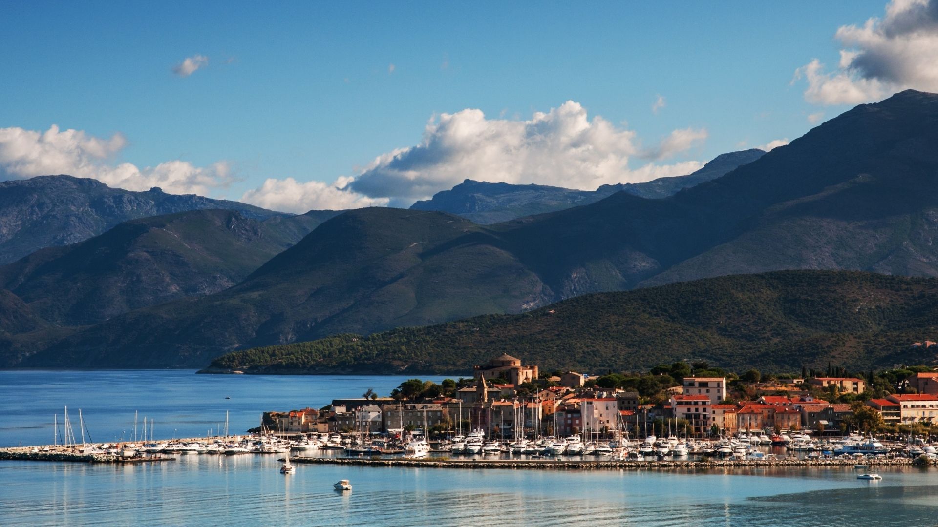
Day 5 of 7 · Calvi → Saint-Florent
Mid-morning lines off for the thirty-nautical-mile run east along the Balagne coast — the most fertile stretch of Corsica, with olive groves and chestnut orchards visible from the water. Mid-day stop at Île Rousse: the village takes its name from the small reddish-granite islets that sit offshore, and the harbor runs the daily Marseille ferry. Lunch ashore at one of the harbor cafés or back aboard.
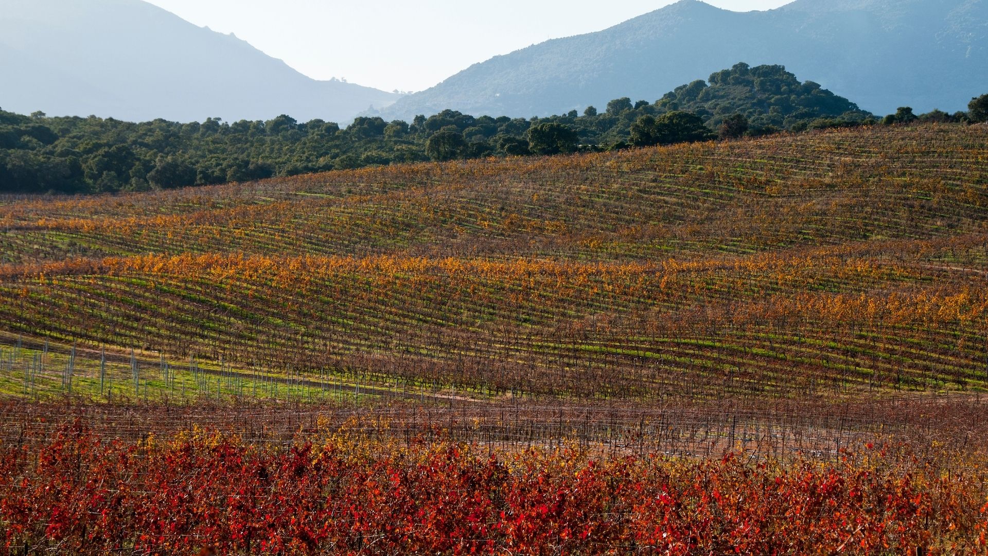
Afternoon, the captain works the longer leg eastbound around the western base of Cap Corse and into Saint-Florent. The peninsula of Cap Corse sticks forty kilometers north into the Mediterranean from the rest of the island, with the Patrimonio vineyards on its western base — Corsica's best-known wine appellation, growing rosé and malvasia on chalk-soil terraces a few kilometers inland from Saint-Florent. Optional shore excursion to the vineyards in the late afternoon (the captain books the visit ahead).
Dinner aboard tonight at Saint-Florent or ashore at one of the harbor restaurants. The Genoese citadel above the harbor lights up after sunset; the village is small enough to walk in twenty minutes.
Day Highlights
Day 6 of 7 · Cap Corse + return
Slow Saint-Florent morning. Optional walk into the village for coffee, a final tender into the Patrimonio side if anyone missed the vineyard visit. By mid-morning, the captain calls the day's route based on weather: the maestrale-up option is a direct return southwest along the Balagne coast back toward the Gulf of Porto; the maestrale-settled option is a twenty-five-mile loop up the west coast of Cap Corse to Nonza and a few of the smaller terraced villages, and back south.
If the Cap Corse loop runs, Nonza is the marquee stop. The village sits on a clifftop with a single Genoese watchtower and a black-volcanic-rock beach below — a leftover from a former asbestos quarry that closed in the 1960s and is now a striking shoreline texture you don't see anywhere else on the cruising ground. A vertical-ladder access drops from the village to the beach for guests who want to walk down. Lunch aboard mid-day, slow afternoon at anchor in one of the smaller coves on the southwest side of Cap Corse.
Late afternoon, the captain works the southbound run back toward the Calvi area or further south depending on how many miles are left for the final return day. Dinner aboard tonight, anchored in the lee of the maestrale wherever the day ended.
Day Highlights
Day 7 of 7 · Final return south
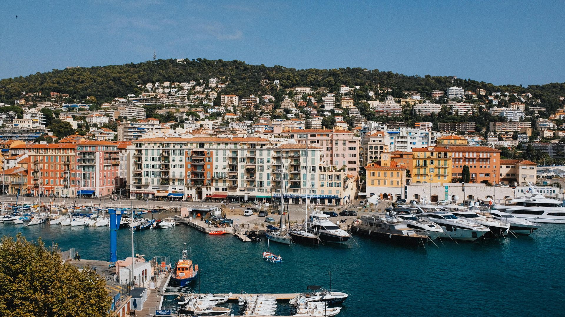
Last full day at anchor. Slow morning swim and breakfast on deck. Mid-morning lines off for the twenty-five-nautical-mile southbound run along the western coast to a final stop at Propriano — the head of the Gulf of Valinco, with sand beaches on the south side and a working harbor at the village. Lunch ashore at one of the harbor cafés or back aboard.
Afternoon, the captain works the final fifteen miles south around the Punta di Senetosa and into the Gulf of Ajaccio. Settle into Marina d'Ajaccio in the early evening. Walk into Ajaccio's old town if you have the energy — the central pedestrian streets are small enough to cover in an hour, and a final lunch or aperitif at one of the seafront restaurants is the unhurried close most groups take.
Final chef-prepared dinner aboard tonight, anchored in the marina with the day's last light over the gulf. Pack at your own pace; your captain has the morning's transfer logistics already squared away.
Day Highlights
Day 8 · Departure
A last slow breakfast aboard at Marina d'Ajaccio, a final swim off the stern if the harbor allows, and disembarkation by mid-morning. Your crew handles the transfer logistics: AJA is ten minutes by taxi, with direct summer flights to Paris, Marseille, Nice, Lyon, London, and a handful of additional European hubs. From the US, most guests connect through Paris-Charles de Gaulle. Step off with a UNESCO World Heritage marine reserve, a Genoese citadel, a Greek-Orthodox church, and a bottle of Patrimonio rosé behind you, and the kind of week that makes most Mediterranean charter guests come back for the cross-strait route the next year.
Want to share or come back to this voyage later?
Bookmark this voyage →Crewed Itinerary · Sardinia & Corsica
This is the do-it-all premium week — a seven-day one-way charter from Olbia on the Costa Smeralda to Monaco's Port Hercule, taking in Sardinia's granite coast, Bonifacio's medieval citadel, Calvi's Genoese fortress, and the heart of the French Riviera at Saint-Tropez, Cannes, Cap Ferrat, and Monaco. Roughly two hundred and fifty nautical miles end to end, with two seventy-plus-nautical-mile days at sea.
The route is motor-only, no matter how good the captain is. The seventy-mile Bonifacio-to-Calvi leg and the eighty-mile Calvi-to-Saint-Tropez leg are too much ground for a sailing yacht to cover in daylight without compromising the days at each end. A planing motor yacht runs each in four to five hours and the schedule reads comfortable; on a sailing yacht the same legs take ten to twelve hours and the trip becomes a passage week rather than a charter week. Most guests on this route are booking a forty-meter-plus motor yacht out of the Costa Smeralda fleet. Your professional captain and private chef handle the rest.
This is the do-it-all premium French Riviera itinerary — a 7-day one-way from Olbia on Sardinia's Costa Smeralda all the way to Monaco's Port Hercule. Two countries, three islands (Sardinia, Corsica, the Lerins), and the heart of the Côte d'Azur in one week: Costa Smeralda, Bonifacio, Calvi, Saint-Tropez, Cannes, the Lerins Islands, Cap Ferrat, and Monaco. About 250 nautical miles total — two days at sea push 70+ nm.
Motor-only, no matter how good the captain is. The Bonifacio-to-Calvi (70 nm) and Calvi-to-Saint-Tropez (80 nm) legs are too much ground for a sailing yacht to cover in daylight without compromising the days at each end. A planing motor yacht runs each in 4–5 hours and the schedule reads comfortable. Most guests on this French Riviera itinerary are booking a 40m+ motor yacht out of the Costa Smeralda fleet.
Day 1 of 7 · Olbia → Costa Smeralda
Your charter begins at Marina di Olbia, a fifteen-minute taxi ride from Olbia (OLB) airport. Your captain and chef meet you on the dock, walk you through the yacht, stow the luggage, and cover the chart for the days ahead — including the two longer at-sea days mid-week, which the captain runs early in the morning before the breeze builds. The marina is deep-water capable for any size yacht, and the early afternoon is yours to settle in.
Provisioning squared away, lines off for the short sixteen-nautical-mile run northeast around Capo Figari and into the Costa Smeralda. The Costa Smeralda is the most concentrated stretch of granite coastline in the Mediterranean; Pevero Bay sits just south of Porto Cervo, framed by two white sand beaches and protected from any wind direction the Mistral might be blowing.
First night at anchor in Pevero or stern-to at Porto Cervo Marina. Chef-prepared welcome dinner aboard — Sardinian seafood, a glass of Vermentino di Gallura, and the lights of the Costa Smeralda coming up across the bay. The trip is built around the next six days; the first night is the slow start.
Day Highlights
Day 2 of 7 · Sardinia → Corsica
Mid-morning lines off for the twenty-five-nautical-mile crossing of the Strait of Bonifacio. The captain checks the morning's wind forecast at first light: when the Mistral is settled, the strait is flat enough to swim across; when it's blowing twenty-five-plus, the boat may push the crossing to the early afternoon. A swim stop at the Lavezzi Islands — French marine reserve in the middle of the strait — typically anchors the mid-morning of the day.
From Lavezzi the run into Bonifacio takes another forty-five minutes. The harbor approach is unforgettable: cut into the limestone cliffs, with the haute ville rising directly above. Stern-to mooring inside the marina or anchor outside; the captain handles the booking. Walk the haute ville — the medieval walled town built on the cliff-top peninsula — in the late afternoon, the King of Aragon Stairway down and back if the group is up for it.
Dinner ashore tonight at one of the stone-walled taverns in the haute ville: charcuterie de Corse, fresh-grilled fish, and a glass of Patrimonio rosé. Or aboard with the haute ville lit up across the harbor.
Day Highlights
Day 3 of 7 · Long leg up Corsica's coast
Long day. The captain runs the seventy-nautical-mile leg up Corsica's west coast in the morning, before the maestrale builds — a planing motor yacht handles the leg in four to five hours, getting you into Calvi by early afternoon. The route passes the Calanques de Piana, the entrance to the Gulf of Porto, and the UNESCO Scandola Nature Reserve on the port side mid-day. Guests on the dedicated Corsica West Coast itinerary anchor inside Scandola; on this route, you see the red cliffs from the water as the boat passes.
By early afternoon you're rounding the western headland of Calvi Bay and into the marina or the bay itself. Calvi sits at the head of a five-mile crescent of fine sand backed by snow-capped mountains; the Genoese citadel rises above the marina on the western headland, occupied by Nelson in 1794 (where he lost his right eye to a French mortar shell) and home to the local legend that Christopher Columbus was born inside its walls.
Afternoon and evening ashore. Walk the citadel, drop into one of the harbor cafés or beach clubs, and dinner ashore tonight at one of Calvi's harbor restaurants. Or aboard with the citadel lit up across the bay.
Day Highlights
Day 4 of 7 · Cross to the French Riviera
Longest leg of the trip. The captain runs the eighty-nautical-mile crossing from Calvi to Saint-Tropez early in the morning — a planing motor yacht handles the leg in five hours; on a sailing yacht the same crossing takes twelve. Open-water passage across the Ligurian Sea, with no scheduled stops; the boat is moving the whole time and the day is for relaxing on deck rather than running a tight schedule.
By early afternoon, the boat is rounding the headland into Saint-Tropez Bay. Stern-to mooring at the old port quay (the captain holds a slot in advance) or anchor in the bay outside. Saint-Tropez itself is a small old fishing village — the harbor is still working, the pastel buildings above the quay are protected, and the high-season summer crowd is concentrated in a few specific bars and beach clubs.
Afternoon ashore: walk the old town, lunch at Sénéquier on the quay if the table works, and a tender ride east to Pampelonne Beach (three miles of fine sand with Club 55, Nikki Beach, and Tahiti Plage along the dunes). Dinner aboard tonight or ashore at one of the harbor restaurants — the captain books ahead.
Day Highlights
Day 5 of 7 · Saint-Tropez → Cannes
Slow morning at Saint-Tropez. Optional walk through the morning market on the Place des Lices (Tuesday and Saturday), or breakfast aboard before lines-off. By mid-morning, the captain runs the thirty-nautical-mile leg east along the coast past the Massif de l'Estérel — the red volcanic-rock coastline that drops straight into the sea between Saint-Tropez and Cannes. The route is mostly inside the coast, with a stop possible at Théoule-sur-Mer if the group wants a swim.
Mid-day arrival into the Bay of Cannes. The captain calls Cannes harbor or the Lerins Islands anchorage — the Lerins (Sainte-Marguerite and Saint-Honorat) sit two miles offshore, and the smaller of the two (Saint-Honorat) holds an active Cistercian abbey where the monks make their own wine and run a public lunch service. Lunch at the abbey if the table works; otherwise lunch ashore at one of the Croisette beach clubs.
Afternoon and evening in Cannes. The Croisette runs the length of the seafront — palm-lined, beach clubs on one side, the harbor on the other. The Cannes Film Festival venue (Palais des Festivals) sits at the western end. Dinner ashore tonight or aboard with the harbor lights coming up.
Day Highlights
Day 6 of 7 · Cannes → Cap Ferrat
Slow morning in Cannes. Lines off mid-morning for the twenty-nautical-mile coastal hop east, past Cap d'Antibes and into Antibes itself. Antibes' Port Vauban is one of the largest yacht harbors in the Mediterranean, with the medieval ramparts and the Picasso Museum (housed in the Château Grimaldi) directly behind the quay. Lunch ashore in the old town at one of the rampart-side restaurants, or a quick walk through the daily covered market.
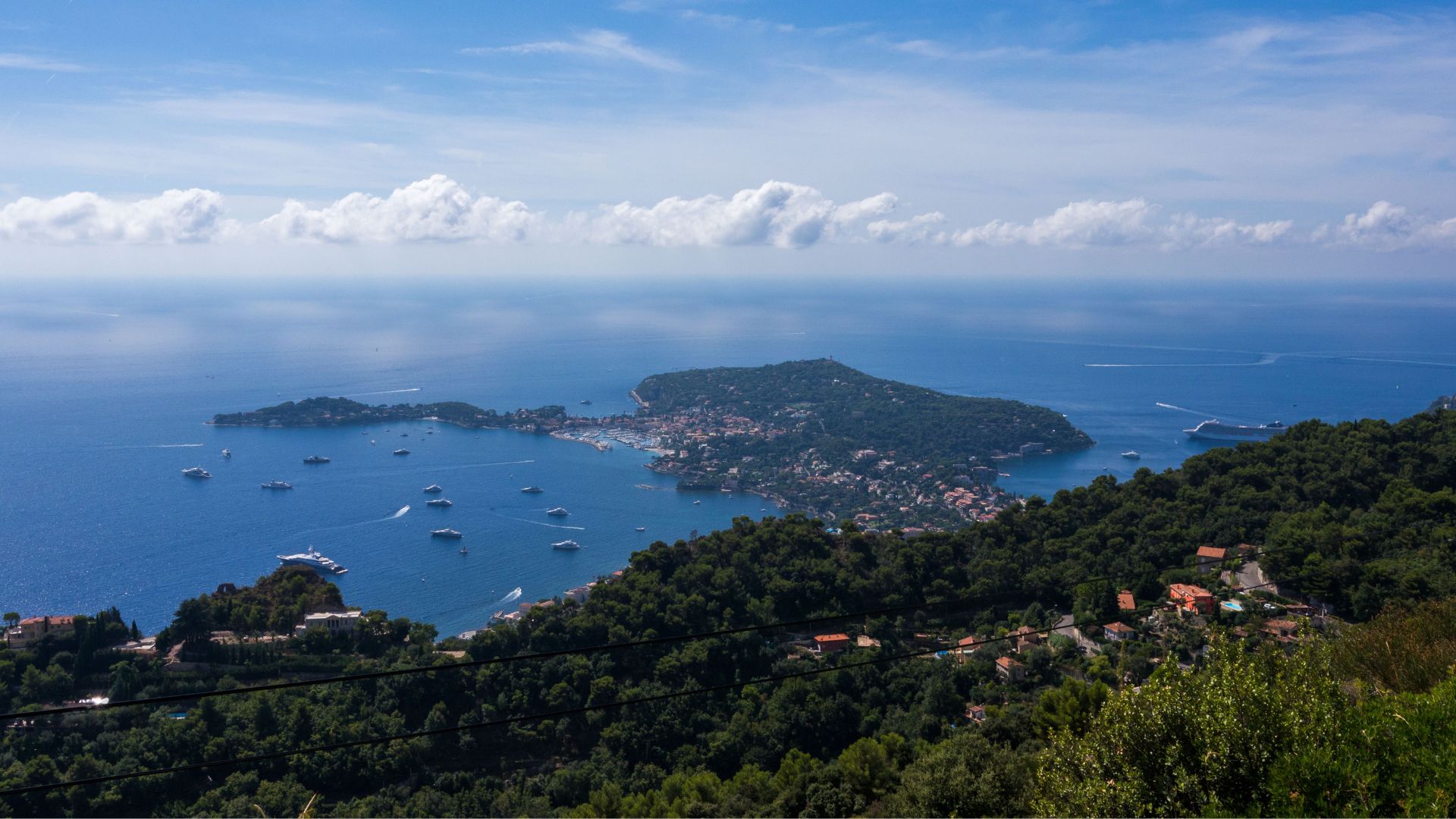
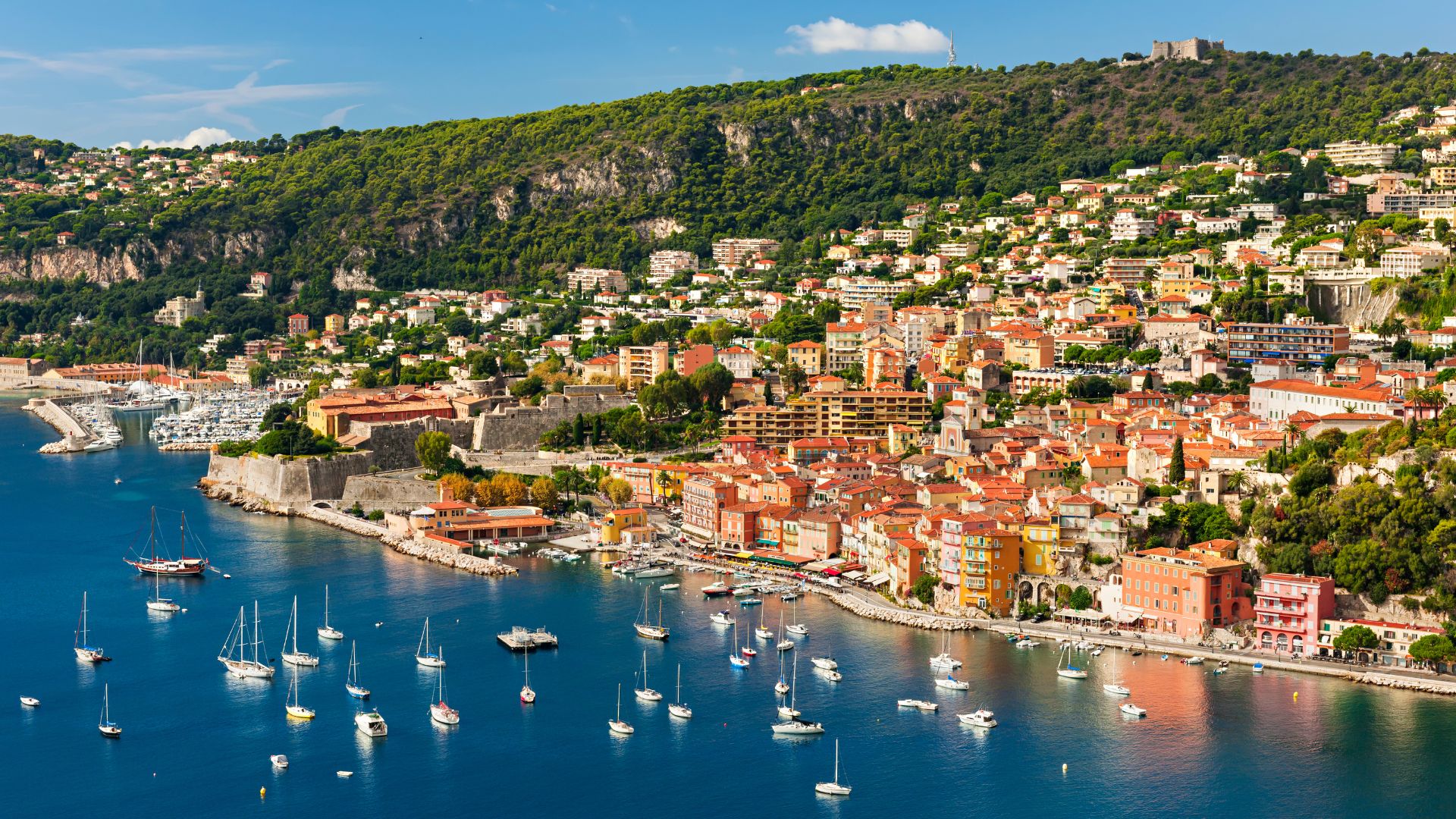
Afternoon, the captain works the run east past Nice and into Villefranche Bay. The bay is a deep horseshoe between Cap Ferrat and Mont Boron — the deepest anchorage on the French Riviera, sheltered in any direction the wind might be blowing, and the standard overnight stop for guests on this route. Cap Ferrat's villa coast sits on the eastern shore: three kilometers of villa-lined headland between Nice and Monaco, with the Villa Ephrussi de Rothschild the only one with public access.
Evening in Villefranche. Walk the old town in the late afternoon — the medieval Rue Obscure (a covered street that runs the length of the seafront) is the marquee piece. Dinner aboard tonight, anchored in the bay, with the lights of Villefranche running up the hillside above and the lights of Nice and Monaco visible from the deck.
Day Highlights
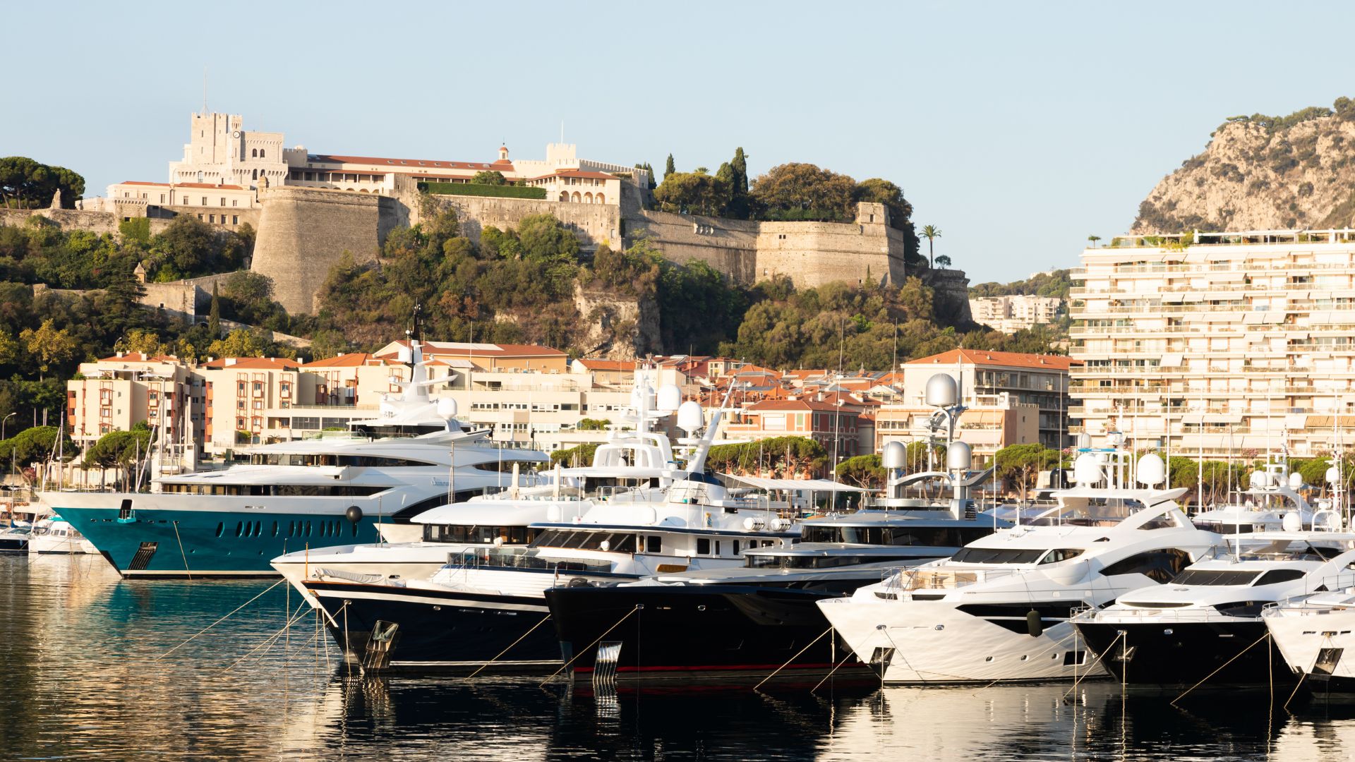
Day 7 of 7 · Final approach to Monaco
Last full day. Slow morning at Villefranche — swim, breakfast on deck, optional tender into the old town for coffee. By late morning, lines off for the short five-nautical-mile final approach east into Monaco's Port Hercule.
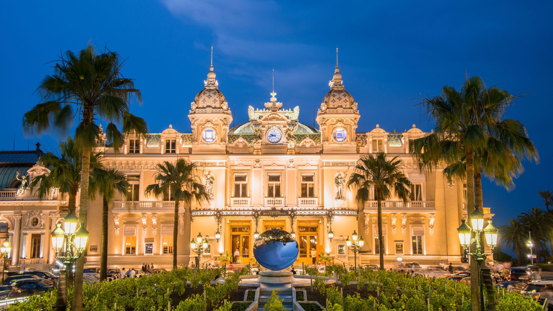
Port Hercule is the only deep-water harbor on the Riviera between Italy and France — megayachts side-tied along the quay during the season, with the principality rising directly above. The Casino square (Place du Casino) sits at the top of the rock; the Grand Prix circuit runs through the streets and the marina is part of the Sainte-Dévote-to-Tabac stretch of the course; the Prince's Palace overlooks the harbor from the western headland.
Afternoon and evening ashore. Walk the Casino square, drop into the Hôtel de Paris bar opposite, walk up to the Prince's Palace if the group has the energy. Dinner aboard tonight at Port Hercule with the harbor lights coming up against the cliffs, or ashore at Le Louis XV (the Alain Ducasse restaurant inside the Hôtel de Paris) if the booking lined up. Final chef-prepared dinner aboard the more common pick on most charters — slower close, the trip's last full meal at anchor.
Day Highlights
Day 8 · Departure
A last slow breakfast aboard at Port Hercule, a final tender into the harbor walk if the group wants one, and disembarkation by mid-morning. Your crew handles the transfer logistics: Nice (NCE) is thirty minutes by car or five minutes by Heli Air Monaco helicopter, with direct flights to most US East Coast hubs and essentially every major European city. Step off with the granite coast of Sardinia, the haute ville at Bonifacio, the Genoese citadel at Calvi, the old port at Saint-Tropez, the Croisette at Cannes, the villa coast of Cap Ferrat, and the Casino square at Monaco all behind you, and the kind of week that's hard to top inside seven days anywhere in the chartering industry.
Want to share or come back to this voyage later?
Bookmark this voyage →
When to go, what it costs, and how to get there — the practical answers guests ask before booking a Sardinia & Corsica crewed yacht charter.
Julio y agosto son las semanas de mayor reserva de la temporada en el Mediterráneo occidental. Las temperaturas diurnas rondan los 30 °C, las del agua alcanzan su máximo en torno a los 26 °C y el Mistral se establece con regularidad casi todas las tardes — un viento térmico del NO que impulsa buena parte de la navegación. El destino está en su momento más concurrido desde el Ferragosto (15 de agosto) hasta final de mes, cuando el tráfico europeo de yates alcanza su pico y los restaurantes de Costa Smeralda se reservan con semanas de antelación. Los mejores yates y tripulaciones se reservan con nueve a doce meses de adelanto para estas fechas, y las tarifas suben entre un veinticinco y un cuarenta por ciento respecto a los meses de temporada media. El Mistral puede soplar con fuerza — de veinticinco a treinta y cinco nudos en rachas prolongadas — y retrasar un cruce del estrecho un día; el capitán lee el pronóstico y ajusta la ruta en consecuencia.
Junio y septiembre son el mejor equilibrio del año. Los vientos alisios son constantes, el agua ronda los 24 °C y sigue siendo perfecta para bañarse hasta principios de octubre, los restaurantes y tabernas tienen mesa, y las tarifas bajan entre un veinte y un treinta por ciento respecto a la temporada alta. La mayoría de los habituales del Mediterráneo occidental reservan uno de estos dos meses — junio por la claridad del agua antes del calor de agosto, septiembre por las bahías tranquilas después de que se retome el curso escolar europeo. Finales de mayo y principios de octubre también son viables para quienes puedan viajar fuera del calendario escolar; agua algo más fresca, tarifas más bajas y algún Maestrale ocasional (un sistema frontal del NO), aunque el capitán planifica la ruta teniendo esto en cuenta. La temporada de viajes en yate abarca aproximadamente de mayo a octubre; de noviembre a abril es temporada baja y la mayor parte de la flota está fuera del agua.
$30,000–$100,000 per week
Los viajes en yate con tripulación por Cerdeña y Córcega suelen tener una tarifa de alquiler de yate de entre 30.000 y más de 100.000 dólares por semana, según el tamaño del yate, el año de construcción y la tripulación. El inventario de Costa Smeralda tiende a ser más caro que el de otros destinos del Mediterráneo — los amarres para yates de más de cien metros en Porto Cervo elevan el extremo superior muy por encima del rango griego o croata. Cerdeña y Córcega operan con el modelo mediterráneo de gastos adicionales — diferente al modelo todo incluido habitual en el Caribe. La tarifa base cubre únicamente el yate y la tripulación. Alimentación, bebidas, combustible, amarre en marina, tasas portuarias, agua, electricidad y cualquier impuesto de navegación se abonan a través de una APA (Asignación Anticipada de Provisiones), financiada por adelantado con el 30 o el 35 por ciento de la tarifa base y liquidada al final del viaje. La propina a la tripulación ronda el 10 o el 15 por ciento en el Mediterráneo — inferior al 15 o 20 por ciento del Caribe — y se entrega directamente al capitán en el desembarque. El IVA del alquiler se paga en el puerto de embarque, y solo allí: el IVA italiano para el alquiler de yates es del 22 por ciento sobre la tarifa base para yates que embarquen en un puerto italiano (Olbia, Cagliari); el IVA francés es del 20 por ciento para los que embarquen en un puerto francés (Ajaccio, Calvi). Un único IVA, no los dos, independientemente de las fronteras que cruce la ruta. Los viajes en yate en Cerdeña y Córcega se hacen de sábado a sábado como norma — el día de rotación habitual en el Mediterráneo.
About chartering in Sardinia & Corsica.
We charter across the Western Mediterranean. Here are some other excellent alternatives.

Four cruising grounds in one country — the Amalfi Coast, Sardinia & Corsica, Sicily and the Aeolian Islands, the Italian Riviera south to Tuscany. The hardest part of an Italy yacht charter is choosing which week to take first.

Cliff-stacked villages and long lunches the tender reaches — the Italian summer the boat makes possible, anchored under the Faraglioni at sundowners and tied up in Amalfi by midnight.

Stromboli erupting off the anchorage at Panarea, the Greek theatre at Taormina with Etna smoking behind, and the Cappella Palatina at Palermo's Norman Palace — the Mediterranean's only active-volcano cruising ground and the Italian week most guests book the second time they come.

Portofino's harbor amphitheater, the Cinque Terre's cliff villages, Portovenere's painted waterfront, and the Tuscan islands south to Elba and Argentario. The quieter Italian week for guests who want village character, harbor restaurants, and lower-density anchorages without Amalfi's August intensity.

Monaco's Port Hercule, Cap Ferrat's villa coast, Cannes and Antibes in the central corridor, and Saint-Tropez at the west end. The French Riviera is the western Mediterranean's maximum-glamour yacht week: shorter passages, premium dockage, Michelin density, and the visible harbor theater guests are usually booking on purpose.

Mallorca's mountain coast on one side, Ibiza and Formentera's clearer water and sand-bottomed coves on the other, and the yacht-only Cabrera National Park between them — three weekly itineraries from Palma or Ibiza Town.
Fill out our quick form and we'll dive into your unique preferences — from adventure-packed itineraries to pampered escapes. Whether you're a seasoned voyager or new to charters, we'll tailor recommendations just for you.
With over fifteen years of experience, we'll match you with the yacht that fits your style, group, and itinerary. We work directly with the captains and crews across our list — so the recommendation is built around the right boat-and-crew fit for your week, not whatever's easiest to book.
Once your yacht is booked, we'll take care of logistics: paperwork, reminders, and personalized resources to help you plan. From arrival planning to must-visit spots, we'll make your charter as seamless as it is unforgettable.

¿Qué esperar de un alquiler de yate privado con tripulación?
Conocé qué hace únicos a estos viajes en yate: servicio personalizado, gastronomía gourmet y un sinfín de aventuras y momentos de relax.

¿Cómo es el proceso de reserva?
Nuestro equipo se encarga de todo: desde tu primer consulta hasta que zarpás. Todo fluye de forma simple.

¿Cuánto cuesta un alquiler de yate con tripulación?
Entendé los distintos tipos de precios, lo que está incluido y lo que no.

Logística: planes probados para un inicio sin estrés
Planificá tu llegada con facilidad. Te damos tips sobre vuelos, traslados y todo lo necesario para arrancar relajado.
Alquiler de yate de luna de miel
Comience su matrimonio en un yate privado. Explore playas solitarias, gastronomía gourmet y atardeceres inolvidables en el Caribe.
Alquiler de yate familiares
Un alquiler de yate con tripulación es perfecto para familias de todas las edades. Seguro, divertido y con servicio completo — sus hijos nunca lo olvidarán.

Preguntas frecuentes sobre alquileres de yate con tripulación
Obtenga respuestas a las preguntas más comunes sobre alquiler de yate con tripulación, desde precios y propinas hasta qué incluye y qué llevar.

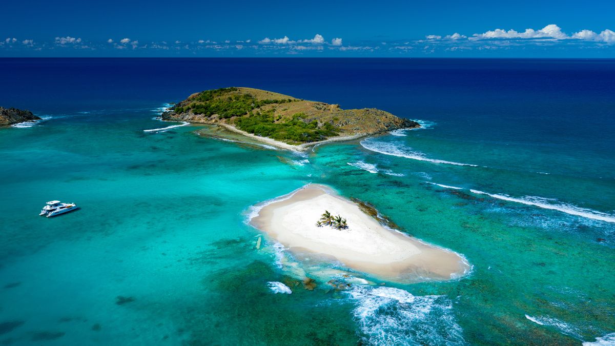
Alquiler de yate con tripulación en las Islas Vírgenes Británicas
Las Islas Vírgenes Británicas son el destino #1 de alquiler de yate con tripulación en el Caribe. Navegaciones cortas, aguas protegidas y bahías de clase mundial.

Guía de Alquiler de Yate con Tripulación en Islas Vírgenes Británicas
Todo lo que necesitás saber antes de tu viaje en yate con tripulación en las Islas Vírgenes Británicas — precios, lista de equipaje, itinerario y cómo llegar.
Alquiler de yate con tripulación en las Bahamas
Explore las Exumas en un yate privado con tripulación. Cerdos nadadores, bancos de arena y algunas de las aguas más cristalinas del mundo.
Alquiler de yate con tripulación en el Caribe
Alquiler de yate todo incluido con tripulación en todo el Caribe — Islas Vírgenes Británicas, Bahamas, Islas Vírgenes de EEUU, St. Martin, Antigua y más.